AREA 13 - GREAT SALT LAKE DESERTUpdated:ĀApril 3, 2011 |
|
|
MANAGEMENT Five Proposed Determination of Water Rights books have been published. The Grouse Creek book was published in 1966, the Park Valley book in 1968, the Snowville-Promontory Point book in 1969, the Southwestern Box Elder book in 1970, and a supplemental book in 1971, but no final decrees have been issued. No other court decrees have been issued for this area. There are no state-administered distribution systems in this area. Click here to see statistics for this area. SOURCES Surface Water - Surface waters are limited and generally considered to be fully appropriated. Any new appropriations would be carefully reviewed on their individual merits. New surface diversions and uses must be accomplished by change applications filed on owned or acquired existing rights. Non-consumptive use applications, such as hydroelectric power generation, will be considered on their individual merits. Applications where the point of diversion is below the 4210-foot elevation and around the Great Salt Lake require compliance with the leasing requirements of the Division of Forestry, Fire & State Lands and a State Engineer's determination of best public interest. Ground Water - Valley locations are open for ground-water applications, canyon areas above full appropriated springs and streams are closed. However, there are some specific policies for certain areas which are mentioned below. Filings for the domestic use of one family, irrigation of 0.25 acres, and the watering of a reasonable number of livestock (total diversion of 1.73 acre-feet per year (af/yr)or less) are allowed throughout the area where there is no existing water system to supply residences. In some parts of the area, wells diverting up to 1.73 af/yr for other uses could be allowed on an individually reviewed basis. Changes from surface to underground sources, and vice versa, are also considered on their individual merits, with emphasis on their potential to interfere with existing rights and to ensure that there is no enlargement of the underlying rights. Fixed-time or temporary projects are evaluated in a similar fashion. Generally, applicants are given three years to complete their project. Filings for certain valley locations are addressed as follows: GENERAL Applications are advertised in the Box Elder News Journal in Brigham City or The Leader in Tremonton. Filings that may involve the diversion of water in Utah for use in Idaho or Nevada (export) would be subject to the special criteria the statutes require for such projects. The general irrigation diversion duty for this area, which the State Engineer uses for evaluation purposes, is 3.0 acre-feet per acre per year. The consumptive use requirement is determined from the publication Consumptive Use of Irrigated Crops in Utah, Research Report 145, Utah State University, 1994, unless the applicant submits other data for consideration. This area is administered by the Northern Regional Office in Logan. Other Requirements The Water Right applicant is strongly cautioned that other permits may be required before any physical development of a project can begin and it is the responsibility of the applicant to determine the applicability of and acquisition of such permits. In order to avoid delays and ensure that Water Right approvals conform to applicable local ordinances, applicants should contact local governmental entities in advance to determine what ordinances are in place that affect the proposed project and to make sure that Water Right filings conform to those ordinances. The approval of a Water Right application does not imply any approval of a project by any other governmental entity. Approval of the project proposed in the Water Right application should be obtained from local governmental entities as necessary to implement a project. REFERENCES Technical Publication No. 25, Hydrologic Reconnaissance of Curlew Valley, Utah and Idaho; Utah Department of Natural Resources; 1969. Technical Publication No. 26, Hydrologic Reconnaissance of the Sink Valley Area, Tooele and Box Elder Counties, Utah; Utah Department of Natural Resources; 1970. Technical Publication No. 29, Hydrologic Reconnaissance of Grouse Creek Valley, Box Elder County, Utah; Utah Department of Natural Resources; 1970. Technical Publication No. 30, Hydrologic Reconnaissance of the Park Valley Area, Box Elder County, Utah; Utah Department of Natural Resources; 1971. Technical Publication No. 33, Hydrologic Reconnaissance of Hansel Valley and Northern Rozel Flat, Box Elder County, Utah; Utah Department of Natural Resources; 1971. Technical Publication No. 37, Hydrologic Reconnaissance of the Blue Creek Valley Area, Box Elder County, Utah; Utah Department of Natural Resources; 1972. Technical Publication No. 38, Hydrologic Reconnaissance of the Promontory Mountains Area, Box Elder County, Utah; Utah Department of Natural Resources; 1972. Technical Publication No. 41, Hydrologic Reconnaissance of Pilot Valley, Utah and Nevada; Utah Department of Natural Resources; 1973. Technical Publication No. 42, Hydrologic Reconnaissance of the Northern Great Salt Lake Desert and Summary Reconnaissance of Northwestern Utah; Utah Department of Natural Resources; 1974. Technical Publication No. 45, Water Resources of the Curlew Valley Drainage Basin, Utah and Idaho; Utah Department of Natural Resources; 1974. Basic Data Report No. 30, Selected Ground-Water Data, Bonneville Salt Flats and Pilot Valley, Western Utah; Utah Department of Natural Resources; 1978. Water-Resources Investigative Report 95-4173, Simulated Effects of Proposed Ground-Water Pumping in 17 Basins in East-Central and Southern Nevada; U.S. Geological Survey; 1995 (viewing this document requires the DjVu browser plugin available from LizardTech) UGS Special Study 126, Geology and Ground-Water Chemistry, Curlew Valley, Northwestern Utah and South-Central Idaho - Implications for Hydrogeology; 2008 MODELING Regional Ground-Water Flow, Carbonate-Rock Province, Nevada, Utah, and Adjacent States; USGS Open-File Reports 93-170 and 93-420; 1993. PREVIOUS PAGE UPDATES None available. |
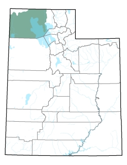
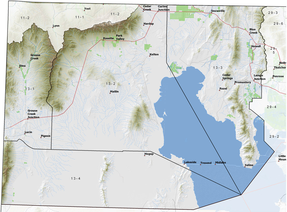
Policy area in green,
click on the map for more detail DESCRIPTION Covering two-thirds of Box Elder County from T3N to T15N, this large and relatively dry area includes Blue, Deep, Pine, Dove, Muddy, Rosebud, and Grouse Creeks and the northwestern part of the Great Salt Lake. It is bordered on the north by Idaho and the Raft River Range, on the east by the Lower Bear River drainage and the remainder of the Great Salt Lake, on the south by the southern part of the Great Salt Lake Desert, and on the west by Nevada. The highest point in the area is 9,601 foot George Peak, while the lowest is the Great Salt Lake at about 4,200 feet, giving a total relief of about 5,400 feet. |
|
|
|