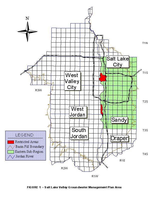
Figure 1 -- Salt Lake Valley Groundwater Management Plan
Area
Figure 2 -- Method Used to Distribute Groundwater Withdrawals
1.0 Introduction
1.1 Background Information
The State Engineer implemented an Interim Groundwater
Management Plan (Interim Plan) in Salt Lake Valley in April of 1991.
The purpose of the Interim Plan was to address the over-appropriation
of groundwater rights in Salt Lake Valley and to protect the quality of
the resource while the United States Geological Survey (USGS) in cooperation
with the public water suppliers and the Division of Water Rights conducted
studies to determine the effects of large amounts of groundwater withdrawals
on the water quality. These studies have been completed and are listed
below:
The Interim Plan was intended to guide water management during the period of time the USGS studies were being conducted. In developing this long-term management plan for the valley, several provisions were added to the Interim Plan and some provisions were modified to reflect the information obtained from the studies. This groundwater management plan is intended to guide the long-term groundwater activities in Salt Lake Valley. This plan is presented as a proposal to the water users in the valley and to other interested parties and will be modified following their review and may also be modified as additional data becomes available. The boundary of the unconsolidated basin-fill material, which makes up the Salt Lake Valley aquifer system, is being used as the boundary of this management plan, as illustrated in Figure 1.
1.2 Modification of the Interim Groundwater Management Plan
The management areas used in the Interim Plan have been
deleted and replaced with a different configuration designed to better
deal with existing and potential problems in the aquifer system. The management
areas of the Interim Plan were based, generally, on water quality data
collected from 1979-1984 (DNR Technical Publication No. 89). The model
has shown that those management areas would not be effective in preventing
adverse effects on the aquifer caused by dense, localized withdrawals.
In addition, the total amount of valley-wide groundwater withdrawals set
forth in the Interim Plan have been modified based on information from
the USGS studies.
1.3 Groundwater Management Plan Objective
The objective of this groundwater management plan is to allow for maximum utilization of the groundwater resource within the constraint of protecting the groundwater resources of Salt Lake Valley. The plan is proposed to help manage the groundwater resource so that water quality and existing water rights are protected. In proposing this groundwater management plan, the State Engineer is using his statutory authority to administer the measurement, appropriation, apportionment, and distribution of the groundwater of Salt Lake Valley.
2.0 Salt Lake Valley Groundwater Management Plan
The following policy guidelines are hereby proposed:
2.1 Groundwater Withdrawal Limits
In order to fulfill the objectives of this management
plan, guidelines have been proposed to help distribute withdrawals on a
regional and localized basis. If area or local withdrawals exceed the allowable
respective withdrawal limits set forth in this plan, the State Engineer
will distribute the water in accordance with the priority dates of the
individual water rights using the following guidelines.
2.1.1 Regional Withdrawals from the Principal Aquifer
Everything in the Salt Lake Valley located to the east
of the Jordan River shall be referred to as the "Eastern Region." The maximum
average amount of withdrawal from the Eastern Region (based on a five year
moving average) shall be 95,000 af/yr. The maximum withdrawal amount permitted
in the Eastern Region in a single year shall be 120,000 acre-feet.
Everything in the Salt Lake Valley located to the west
of the Jordan River shall be referred to as the "Western Region." The maximum
average amount of withdrawal from the Western Region (based on a five year
moving average) shall be 70,000 af/yr. The maximum withdrawal amount permitted
in the Western Region in a single year shall be 90,000 acre-feet.
2.1.2 Sub-Regional Groundwater Withdrawals from the Principal Aquifer
In the Eastern Region there is a relatively large area
of dense groundwater withdrawals. The majority of the groundwater withdrawals
in the Eastern region are taken from that area. For management purposes,
that area shall consist of Township 1 South, Township 2 South, and sections
one through eighteen of Township 3 South, east of the Jordan River as shown
on Figure 1. The maximum average amount of withdrawal from this area (based
on a five year moving average) shall be 85,000 af/yr.
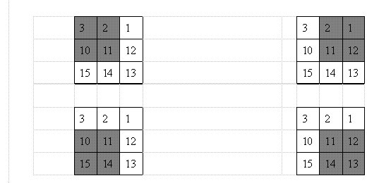
2.1.3 Localized Groundwater Withdrawals from the Eastern Region
A management grid has been set up based on the U.S. Public
Land Survey's system. Under this system, the land is divided into section,
township, and range. Each section is a square measuring approximately one
mile on each side. In this management plan, one management square consists
of any four sections, in a two section by two section configuration.
The maximum groundwater withdrawal rate from the principal aquifer in the Eastern Region for any square (a group of four sections) shall be 12,000 af/yr. Using this method, the squares overlap each other such that each section is actually part of four different management squares. Figure 2, below, illustrates how section 11 is part of four different management squares. Each of the four overlapping squares has a withdrawal limit of 12,000 af/yr.
2.1.4 Groundwater Withdrawals From the Shallow aquifer
Additional withdrawals above the allowable withdrawal
limits set forth in this section will be allowed if such withdrawals are
from the shallow aquifer, provided that such withdrawals do not have an
adverse effect on other water rights.
2.1.5 Groundwater Withdrawals from Restricted Areas
There are two (2) restricted pumping areas currently in
the plan, and are illustrated in Figure 1. These areas are associated with
the following contaminated sites:
2.2 Applications to Change the Point of Diversion, Place of Use, or Purpose of Use
Change applications will be evaluated based upon their
own merits. The evaluation may consider, but will not necessarily be limited
to, potential impact on the following: existing water rights, the aquifer
system as a whole, and overall water quality. The following guidelines
will be used:
In conjunction with all proofs of appropriation and proofs
of change, the State Engineer shall require that the total volume of water
to be certified has in fact been developed and placed to beneficial use.
The State Engineer will review the total operation of a system or water
user to ensure the intent of this requirement is met.
2.4 Well Spacing and Flow Rate
Well spacing and maximum flow rates of wells shall be regulated so a well, when pumped at its maximum flow rate, will not cause more than 12 feet of drawdown on any well with an earlier priority date. Users in a particular area may enter into an agreement to provide a variance from this requirement if it does not interfere with third party rights and also subject to approval by the State Engineer.
2.5 Applications to Appropriate Water and Segregation Applications
Applications to appropriate water from the principal aquifer
will be considered for single family uses in non-subdivision areas where
water is not available from a public water supply system. Applications
to appropriate water will be limited to a maximum annual diversion of 1.0
acre-foot. The uses under such application shall not exceed the domestic
purposes of one family, the irrigation of 0.10 acres, and/or the stock
watering of a maximum of 10 head of livestock. Such rights shall be approved
as fixed time applications for a ten-year period and upon the condition
that when a public water system is available, the users will connect to
the system, the well will be sealed, and the water right abandoned. Upon
expiration of the ten-year period, if a public water supply system is still
not available, such application will be extended upon proper filing of
a request for extension.
All future segregation applications will be critically
reviewed on their individual merits, according to current statutory provisions.
2.6 Extensions of Time for Applications to Appropriate Water
The State Engineer will critically review all future extension
requests on approved applications to appropriate water pursuant to Section
73-3-12 of the Utah Code. In reviewing extension requests, if the State
Engineer finds unjustified delays or a lack of due diligence, he may grant
the request in part (including a reduction in the quantity of water available
under the application), reduce the priority date, or deny the extension
of time request.
2.7 Metering and Annual Reporting of Groundwater Withdrawals
All groundwater wells that have the right to potentially
withdraw 50 acre-feet or more annually shall be equipped with a meter capable
of measuring the instantaneous flow rate and total volume pumped through
the meter. All water users meeting the above criteria shall be required
to submit an annual report to the State Engineer by March 1 of each year
setting forth the quantity of water diverted for each of their wells during
the previous calendar year. Such reports shall summarize the monthly withdrawals
for each well operated. If the water user submits an accurate and complete
annual Utah Water Use Data Form it shall fulfill this requirement.
Owners of all groundwater wells that have the right to
potentially withdraw 250 acre-feet or more annually, shall submit a water
quality report for total inorganics every three years. A copy of the inorganic
analyses performed as per Department of Environmental Quality, Division
of Drinking Water requirements, will satisfy this reporting requirement.
2.8 Monitoring Activities and Aquifer Status Update
The Division will monitor the water quality reports submitted by the water users and give an updated, valley-wide water quality summary every 5 years. The Division will also provide water use information such as valley-wide, regional and localized withdrawals and priority lists.