AREA 15 - TOOELE AND RUSH VALLEYSUpdated: November 3, 2022
|
|
|
MANAGEMENT Three Proposed Determination of Water Rights books and an addendum have been published for this area between 1973 and 1999, however, no pre-trial orders or final decrees have been issued. There are no state-administered distribution systems in this area. Click here to see statistics for this area. SOURCES Surface Water - Surface waters are considered to be fully appropriated. New diversions and consumptive uses in these sources must be accomplished by change applications filed on owned or acquired rights. Non-consumptive use applications, such as hydroelectric power generation, will be considered on their individual merits. The only exception is for small amounts from sources that would otherwise flow to the Great Salt Lake. Ground Water - Tooele Valley is closed to appropriations except for small amounts of shallow ground water (less than 10 feet from the surface) which would otherwise flow to the Great Salt Lake. New diversions and consumptive uses in other sources must be accomplished by change applications filed on owned or acquired rights. Changes from surface to underground sources, and vice versa, are also considered on their individual merits, with emphasis on the existence of a hydrologic tie between the two sources, the potential for interference with existing rights, and to ensure that there is no enlargement of the underlying rights. Non-consumptive use applications, such as hydroelectric power generation, will be considered on their individual merits. Temporary appropriations may be allowed for very short term projects. Applicants are placed on notice that development should be pursued as soon as possible. Extension of time requests will be critically reviewed beyond the initial five-year period. The area is subject to the following State Engineer policies: Tooele Valley - Adopted on April 16, 2008, this policy is presented in greater detail in a subsequent section below. Rush Valley - On July 25, 2019, the State Engineer adopted a new policy to use when considering applications to appropriate and change applications in Rush Valley. A public meeting was held on November 8, 2018 to discuss the proposed policy. See the following:
This policy is summarized below:
The following are excepted from the effect of this proclamation:
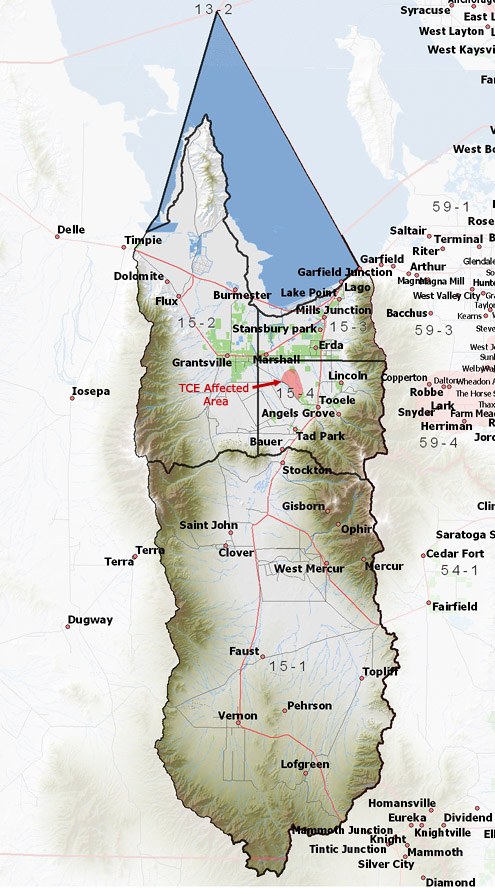
GROUNDWATER MANAGEMENT PLAN Effective February 27, 1996, the Tooele Valley portion of this area is subject to the conditions of the Tooele Valley Ground-water Management Plan. A public meeting was held on July 7, 2004 to discuss the Northeast Boundary Plume and an Amendment to the Tooele Valley Groundwater Management Plan was issued on September 22, 2004, the linked PDF file includes a map of the area discussed. These plans set out to provide a frame work for future ground-water development, be a guide for action on water right applications, to prevent over utilization of the resource, to maintain water quality and to protect prior water rights.TOOELE VALLEY GROUNDWATER CHANGE APPLICATION POLICY As of April 16th, 2008, The State Engineer adopted a new policy to use when considering change applications in Tooele Valley. The policy guidelines provide a methodology for evaluating change applications that propose to move the point of diversion within the Tooele Valley. The new guidelines have two conditions limiting movement:
GENERAL Applications are advertised in the Tooele Transcript. The general irrigation diversion duty for this area, which the State Engineer uses for evaluation purposes, is generally 4.0 acre-feet per acre per year. The consumptive use requirement is determined from the publication Consumptive Use of Irrigated Crops in Utah, Research Report 145, Utah State University, 1994, unless the applicant submits other data for consideration. This area is administered by the Weber River Regional Office in Salt Lake City. Other Requirements The Water Right applicant is strongly cautioned that other permits may be required before any physical development of a project can begin and it is the responsibility of the applicant to determine the applicability of and acquisition of such permits. In order to avoid delays and ensure that Water Right approvals conform to applicable local ordinances, applicants should contact local governmental entities in advance to determine what ordinances are in place that affect the proposed project and to make sure that Water Right filings conform to those ordinances. The approval of a Water Right application does not imply any approval of a project by any other governmental entity. Approval of the project proposed in the Water Right application should be obtained from local governmental entities as necessary to implement a project. REFERENCES Technical Publication No. 4, Ground Water in Tooele Valley, Tooele County, Utah; Utah State Engineer; 1946. Technical Publication No. 12, Reevaluation of the Ground-Water Resources of Tooele Valley, Utah; Utah State Engineer; 1965. Technical Publication No. 23, Hydrologic Reconnaissance of Rush Valley, Tooele County, Utah; Utah Department of Natural Resources; 1969. Technical Publication No. 69, Ground-Water Conditions in Tooele Valley, Utah, 1976-78; Utah Department of Natural Resources; 1981. Technical Publication No. 107, Hydrology and Potential for Ground-Water Development in Southeastern Tooele Valley and Adjacent Areas in the Oquirrh Mountains, Tooele County, Utah; Utah Department of Natural Resources; 1994. Water Circular No. 2, Ground Water in Tooele Valley, Utah; Utah Department of Natural Resources; 1970. Basic Data Report No. 7, Selected Hydrologic Data, Tooele Valley, Tooele County, Utah; Utah State Engineer; 1963. Information Bulletin No. 26, Test Drilling for Fresh Water in Tooele Valley, Utah; Utah State Engineer; 1981. Water Resources
Investigative Report 95-4173, Simulated Effects of Proposed Ground-Water
Pumping in 17 Basins in East-Central and Southern Nevada; Water Resources Investigative Report 99-4014,
Hydrology and Simulation of the Ground-Water Flow System in Tooele Valley, UT; United States Geological Survey; 1999. USGS Scientific Investigations Report 2009-5154, Hydrology and Simulation of Ground-Water Flow in the Tooele Valley Ground-Water Basin, Tooele County, Utah; United States Geological Survey; 2009. USGS Scientific Investigations Report 2011-5068, Hydrogeologic and Geochemical Characterization of Groundwater Resources in Rush Valley, Tooele County, Utah; United States Geological Survey; 2011. USGS Scientific Investigations Report 2014-5213, Steady-State Numerical Groundwater Flow Model of the Great Basin Carbonate and Alluvial Aquifer System; 2014. USGS Scientific Investigations Report 2017-5072, Groundwater Model of the Great Basin Carbonate and Alluvial Aquifer System Version 3.0: Incorporating Revisions in Southwestern Utah and East Central Nevada; 2017. MODELING Regional Ground-Water Flow, Carbonate-Rock Province, Nevada, Utah, and Adjacent States; USGS Open-File Reports 93-170 and 93-420; 1993. Tooele Valley Ground-Water Flow Model, 1994. PUBLIC COMMENTS PREVIOUS PAGE UPDATES July 27, 2004, September 24, 2004, September 10, 2008, April 3, 2011, August 1, 2019 |
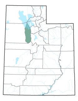
Policy area in green,
click on the map for more detail DESCRIPTION Located on the eastern edge of the Tooele County from T4N to T10S, these two valleys are administered separately because of the weak hydrologic connection they have through South Mountain. This area is bounded on the north by the Great Salt Lake, on the west by the Stansbury and Onaqui Mountains, on the east by the Oquirrh and East Tintic Mountains, and on the south by the Sheeprock Mountains. The highest point in the area is 11,031 foot Deseret Peak, while the lowest is the shore of the Great Salt Lake at about 4,200 feet, giving a total relief of about 6,830 feet. |
|
|
|