AREA 23 - BEAR RIVER/RICH COUNTYUpdated:ĀApril 10, 2011 |
|
|
MANAGEMENT The area was first adjudicated, and a Proposed Determination of Water Rights was published in 1949; an Interlocutory Decree was issued in 1953. Other decrees in this area include the 1919 Otter Creek Decree, the 1924 Woodruff Creek Decree, the 1935 Laketown Big Creek Decree, the 1944 Woodruff Creek Decree, the 1958 Meadow Creek Decree, the 1958 Otter Creek Decree, and the 1969 Woodruff Creek Decree. The area is part of the Bear River Distribution System, which is administered by the Bear River Commissioner. Because this area is part of the Bear River basin, the conditions of the 1955 Bear River Compact apply. Click here to see statistics for this area. SOURCES Surface and Ground Water - Available supplies of surface water are limited. No filings are approved in canyon areas above fully appropriated springs and streams. Valley locations are open for ground-water applications, which are limited to the domestic use of one family, the irrigation of 1/4 acre, and a nominal amount of livestock watering. Applications for larger amounts are subject to individual review. Non-consumptive use applications, such as hydroelectric power generation, will be considered on their individual merits. Changes from surface to underground sources, and vice versa, are also considered on their individual merits, with emphasis on their potential to interfere with existing rights and to ensure that there is no enlargement of the underlying rights. Fixed-time and temporary projects, especially those involving surface waters, are evaluated in a similar fashion. GENERAL Applications are advertised in the Montpelier, Idaho News Examiner. Filings that may involve the diversion of water in Utah for use in Idaho or Wyoming (export) would be subject to the special criteria the statutes require for such projects. The general irrigation diversion duty for this area, which the State Engineer uses for evaluation purposes, is 3.0 acre-feet per acre per year. The consumptive use requirement is determined from the publication Consumptive Use of Irrigated Crops in Utah, Research Report 145, Utah State University, 1994, unless the applicant submits other data for consideration. This area is administered by the Northern Regional Office in Logan. Other requirements The Water Right applicant is strongly cautioned that other permits may be required before any physical development of a project can begin and it is the responsibility of the applicant to determine the applicability of and acquisition of such permits. In order to avoid delays and ensure that Water Right approvals conform to applicable local ordinances, applicants should contact local governmental entities in advance to determine what ordinances are in place that affect the proposed project and to make sure that Water Right filings conform to those ordinances. The approval of a Water Right application does not imply any approval of a project by any other governmental entity. Approval of the project proposed in the Water Right application should be obtained from local governmental entities as necessary to implement a project. REFERENCES Basic Data Report No. 18, Quality of Surface Water in the Bear River Basin, Utah, Wyoming, and Idaho; Utah Department of Natural Resources; 1970. MODELING None available. PREVIOUS PAGE UPDATES None available. |
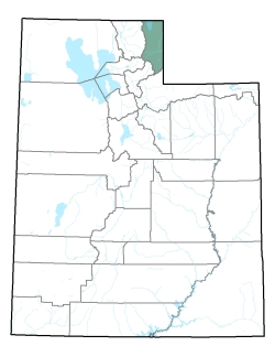
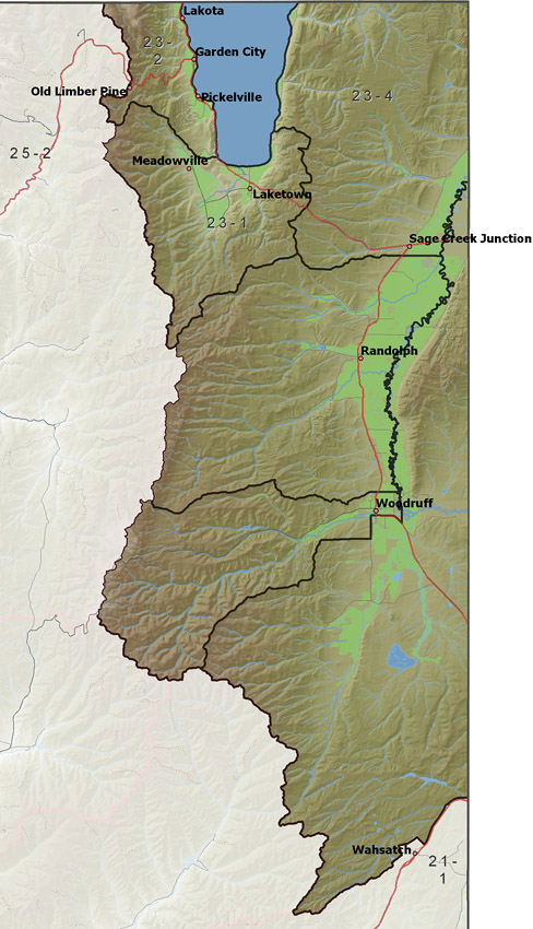
Policy area in green,
click on the map for more detail DESCRIPTION Covering most of Rich County from T5N to T15N, this area includes numerous eastward flowing streams from the Wasatch Range to the Bear River, including Saleratus, Woodruff, Birch, Big, and Otter Creeks. It is bordered on the north by Idaho, on the east by Wyoming, on the south and southwest by the Weber River drainage, and on the west by Cache Valley. Many of these sources have reservoirs which store spring runoff to supplement late season irrigation diversions. This area also contains the south half of Bear Lake and several contributing streams, such as Laketown, North Eden and South Eden Creeks. Bear Lake serves as a storage reservoir for Pacificorp's power generating activities elsewhere in the Bear River basin. The highest point in the area is 9,114 foot Swan Peak, while the lowest is the surface of Bear Lake at about 5,925 feet, giving a total relief of about 3,190 feet. |
|
|
|