AREA 45 - ASHLEY CREEK and BRUSH CREEKUpdated:ĀApril 11, 2011 |
|
|
MANAGEMENT Nine Proposed Determination of Water Rights books were published between 1960 and 2000. Final decrees were issued for the Brush Creek book in 1968 and the Dry Fork book in 2000. There are no state-administered distribution systems in this area. Since this area is part of the Colorado River basin, the conditions of the 1922 Colorado River Compact, the 1944 Mexican Treaty and the 1948 Upper Colorado River Compact and the State Engineer's Colorado River Policy apply. Applications to appropriate or change water are subject to conditions dealing with Green River Endangered Species Protection. Click here to see statistics for this area. SOURCES Surface Water - Surface waters are considered to be fully appropriated, except
for isolated springs. New diversions and consumptive uses in these sources
must be accomplished by change applications filed on owned or acquired rights.
A large block of water under the Flaming Gorge Project has been transferred
to the State of Utah and is available for some of these changes. Filings
made after November 30, 1994, which divert from the Green River between Flaming
Gorge Dam and the confluence with the Duchesne River are subject to bypassing
those flows, during the period of June 22 to November 1, as required by a
state-federal cooperative agreement regarding endangered fish in the Colorado
River basin. Non-consumptive use applications, such as hydroelectric power
generation, will be considered on their individual merits.
GENERAL Applications are advertised in the Vernal Express. Filings that may involve the diversion of water in Utah for use in Colorado (export) would be subject to the special criteria the statutes require for such projects. The general irrigation diversion duty for this area, which the State Engineer uses for evaluation purposes, is generally 4.0 acre-feet per acre per year (af/ac), except in the Dry Fork drainage where it is 4.0 af/ac and the Brush Creek drainage where it is 3.7 af/ac. The consumptive use requirement is determined from the publication Consumptive Use of Irrigated Crops in Utah, Research Report 145, Utah State University, 1994, unless the applicant submits other data for consideration. This area is administered by the Northeastern Regional Office in Vernal. Other requirements The Water Right applicant is strongly cautioned that other permits may be required before any physical development of a project can begin and it is the responsibility of the applicant to determine the applicability of and acquisition of such permits. In order to avoid delays and ensure that Water Right approvals conform to applicable local ordinances, applicants should contact local governmental entities in advance to determine what ordinances are in place that affect the proposed project and to make sure that Water Right filings conform to those ordinances. The approval of a Water Right application does not imply any approval of a project by any other governmental entity. Approval of the project proposed in the Water Right application should be obtained from local governmental entities as necessary to implement a project. REFERENCES Technical Publication No. 15, Water from Bedrock in the Colorado Plateau of Utah; Utah State Engineer; 1966. Technical Publication No. 53, Characteristics of Aquifers in the Northern Uinta Basin Area, Utah and Colorado; Utah Department of Natural Resources; 1976. Technical Publication No. 54, Hydrologic Evaluation of Ashley Valley, Northern Uinta Basin Area, Utah; Utah Department of Natural Resources; 1977. Technical Publication No. 62, Water Resources of the Northern Uinta Basin Area, Utah and Colorado, with Special Emphasis on Ground-Water Supply; Utah Department of Natural Resources; 1978. Technical Publication No. 92, Base of Moderately Saline Ground Water in the Uinta Basin Area, Utah, with an Introductory Section Describing the Methods Used in Determining its Position; Utah Department of Natural Resources; 1976. Basic Data Report No. 25, Streamflow Characteristics in Northeastern Utah and Adjacent Areas, Utah; Utah Department of Natural Resources; 1975. Basic Data Report No. 26, Selected Hydrologic Data, Uinta Basin Area, Utah and Colorado; Utah Department of Natural Resources; 1976. Basic Data Report No. 42, Streamflow Characteristics of the Colorado River Basin in Utah through September 1981; Utah Department of Natural Resources; 1987. Information Bulletin No. 21, Hydrogeology of the Eastern Portion of the South Slopes of the Uinta Mountains, Utah; Soil Conservation Service; 1971. Endangered Fish Recovery Program Documents, Upper Colorado River Endangered Fish Recovery Program MODELING None available. PREVIOUS PAGE UPDATES |

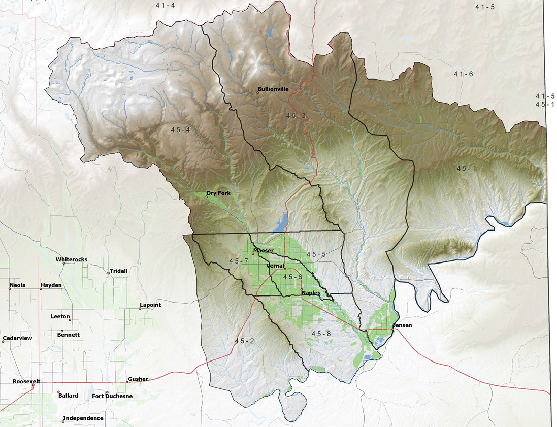
Policy area in green,
click on the map for more detail DESCRIPTION Located in northern Uintah County from T1N to T7S, this area includes the western tributaries of the Green River from its re-entry into Utah to the Duchesne River drainage. The main surface streams in this area are Ashley Creek, Dry Fork, Brush Creek, and Diamond Gulch. This area is bounded on the north by the Uinta Mountains, on the east by Colorado, on the south by the south flank of the Uinta Basin, and on the west by the Duchesne River system. The highest point in the area is 12,240 foot Marsh Peak, while the lowest is where the Green Rivers leaves the area at about 4,670 feet, giving a total relief of about 7,570 feet. |
|
|
|