|
One Proposed Determination of Water Rights book has
been published: the Emigration Canyon in 1983, and a pre-trial order was issued
in 1988. A supplemental decree covering Bertagnole rights was issued in 1990.
There are several other decrees in this area.
There are three state-administered distribution systems in this area. The Utah
Lake-Jordan River Distribution System is administered by the Utah
Lake-Jordan Commissioner. The Lower
Jordan River Distribution System is administered by the Lower Jordan
Commissioner. The Little Cottonwood Distribution System is administered by the Little Cottonwood Creek Commissioner.
This area is subject to the conditions of the Utah
Lake Water Distribution Plan and the Salt
Lake Valley Ground-water Management Plan.
Click
here to see statistics for this area.
Surface Water - All surface waters are fully appropriated. Development of
new, or different, consumptive use projects involving surface water must be
accomplished by change applications based on owned or acquired existing rights.
Non-consumptive use applications, such as hydroelectric power generation,
will be considered on their individual merits. Changes from surface to underground
sources are not allowed in the valley fill. Fixed-time and temporary projects
involving surface waters must be handled by temporary change applications.
Applicants are placed on notice
that development should be pursued as soon as possible, and requests for extensions
of time in which to file proof will be critically reviewed after an initial
five year period.
Ground Water - All ground water is fully appropriated. Development of new,
or different, consumptive use projects must be accomplished by change applications
based on owned or acquired existing rights. Changes from the shallow aquifer
to the principal aquifer will not be approved. Changes will be restricted
by the maximum allowable withdrawal amounts under the management plan. New
wells must be so spaced that when pumped at the maximum authorized flow rate,
the resulting drawdown in any neighboring, earlier priority well will not
exceed 12 feet. Changes from surface to underground sources are not allowed in
the valley fill. Fixed-time and temporary projects must be handled by temporary
change applications. Applicants
are placed on notice that development should be pursued as soon as possible,
and requests for extensions of time in which to file proof will be critically
reviewed after an initial five year period.
Governor's Proclamation 2022-01 - On November 3, 2022, Governor Spencer Cox issued a proclamation suspending new appropriations of surplus and unappropriated waters
in the Great Salt Lake Basin pursuant to Utah Code 73-6-1. To read the press release from the Governor's office,
click here.
To read the proclamation, click here.
A report on the proclamation to suspend appropriations in Great Salt Lake Basin was published on November 22, 2023 and can be read here.
To view a map of areas subject to the proclamation, click here.
The following are excepted from the effect of this proclamation:
- applications for non-consumptive uses,
- applications that include a mitigation plan to offset depletion, and
- applications for small amounts of water, as defined in Utah Code 73-3-5.6, that comply with State Engineer basin policies.
All such applications remain subject to all applicable requirements of state law.
This area is subject to the conditions of the Salt
Lake Valley Ground-water Management Plan, the objectives of which are to promote wise use of the groundwater
resource, to protect existing water rights and to address water quality issues and over-appropriation of ground water
in the valley.
On June 25, 2002, the State Engineer adopted a groundwater management plan which implemented guidelines for evaluating change applications
that propose to move the point of diversion within the Salt Lake Valley. The following guidelines apply for evaluating change applications:
- Change applications that propose to transfer water rights historically supplied from the shallow aquifer to the principal aquifer will not be approved.
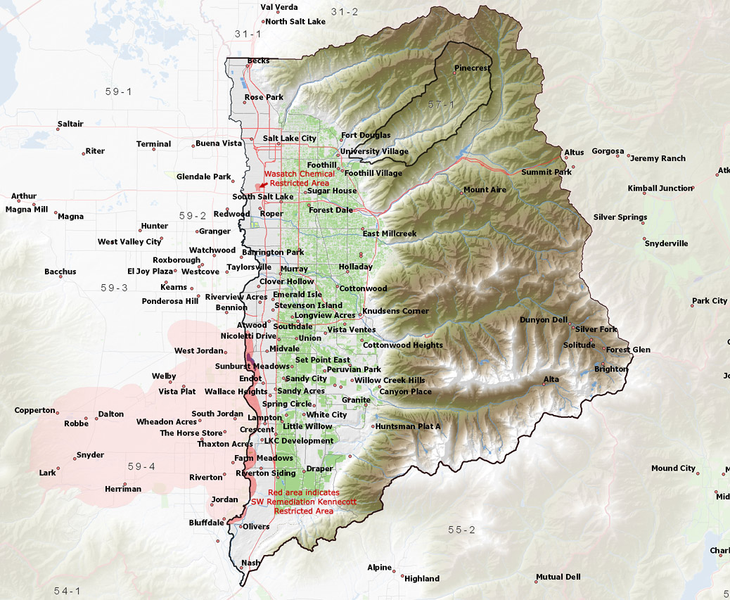
- Change applications that propose to transfer water rights into the eastern region, into the western region, or out of the northern region will not be approved
(See Map).
- Change applications that propose to transfer water rights into a restricted area will not be approved
(See Map).
- Change applications that propose to transfer water rights into the Southwest Remediation Area will be critically reviewed so as not to interfere with the remediation process.
(See Map).
- Change applications that propose to drill a replacement well within a distance of 2,640 feet from the original point of diversion may be approved provided that the application complies with the criteria listed under items 1 and 3, above.
- Change applications that propose to transfer water to other sections will be evaluated using the Transfer Index Number (TIN).
Change applications will not be approved if the the Transfer Index Number for the hereafter point of diversion is greater than the Region Limit unless the applicant can show that:
- There is sufficient reason to believe that existing water rights will not be impaired.
- Compensation and/or adequate replacement water will be provided to existing water right holders if impairment occurs.
- Additional ground-water withdrawals will not significantly reduce water levels, degrade the water quality, or otherwise negatively impact the ground-water system.
For more information regarding the policy please refer to web pages detailing
the Salt Lake Valley Groundwater Management Plan.
To calculate the TIN of a proposed change application, an online
evaluation tool is available.
Applications are advertised in
the Deseret News. The general irrigation diversion duty, which the
State Engineer uses for evaluation purposes, is 5.0 acre-feet per acre per
year (af/ac), except in Emigration Canyon, where the duty is 4.0 af/ac. The
consumptive use requirement is determined from the publication Consumptive
Use of Irrigated Crops in Utah, Research Report 145, Utah State University,
1994, unless the applicant submits other data for consideration. This area
is administered by the Utah
Lake-Jordan River Regional Office in Salt Lake City.
Other requirements
Water Right applicants are strongly cautioned that other permits may be required
before any physical development of a project can begin and it is the responsibility
of the applicant to determine the applicability of and acquisition of such permits.
In order to avoid delays and ensure that Water Right approvals conform to applicable
local ordinances, applicants should contact local governmental entities in advance to
determine what ordinances are in place that affect the proposed project and to make
sure that Water Right filings conform to those ordinances. The approval of
a Water Right application does not imply any approval of a project by any
other governmental entity. Approval of the project proposed in the Water Right
application should be obtained from local governmental entities as necessary
to implement a project.
Technical
Publication No. 31, Water Resources of Salt Lake County, Utah; Utah
Department of Natural Resources; 1971.
Technical
Publication No. 34, Summary of Water Resources of Salt Lake County,
Utah; Utah Department of Natural Resources; 1971.
Technical
Publication No. 82, Seepage Study of Six Canals in Salt Lake County,
Utah, 1982-83; Utah Department of Natural Resources; 1985.
Technical
Publication No. 87, Ground-water Conditions in Salt Lake County, Utah,
1969-83, and Predicted Effects of Increased Withdrawals from Wells; Utah Department
of Natural Resources; 1987.
Technical
Publication No. 89, Chemical Quality of Ground-water Flow in Salt
Lake Valley, Utah, 1969-85; Utah Department of Natural Resources; 1987.
Technical
Publication No. 110A, Chemical Composition of Ground-water, Hydrologic
Properties of Basin-fill Material, and Ground-water Movement in Salt Lake
Valley, Utah; Utah Department of Natural Resources; 1995.
Technical
Publication No. 110B, Numerical Simulation of Ground-water Flow in
Salt Lake Valley, Utah; Utah Department of Natural Resources; 1995.
Technical
Publication No. 110C, Particle Tracking Analysis of Flow Paths and
Travel Times within the Capture Areas of Well Fields in Salt Lake Valley,
Utah; Utah Department of Natural Resources; 1995.
Technical
Publication No. 110D, Numerical Simulation of Solute Transport in
Salt Lake Valley, Utah; Utah Department of Natural Resources; 1995.
Water
Circular No. 1, Ground Water in the Jordan Valley, Salt Lake County,
Utah; Utah Department of Natural Resources; 1965.
Basic-Data
Report No. 4, Selected Hydrologic Data, Jordan Valley, Salt Lake County,
Utah; Utah State Engineer; 1963.
Basic-Data
Report No. 11, Hydrologic and Climatologic Data Collected through
1964, Salt Lake County, Utah; Utah Department of Natural Resources; 1966.
Basic-Data
Report No. 12, Hydrologic and Climatologic Data, 1965, Salt Lake County,
Utah; Utah Department of Natural Resources; 1966.
Basic-Data
Report No. 13, Hydrologic and Climatologic Data, 1966, Salt Lake County,
Utah; Utah Department of Natural Resources; 1967.
Basic-Data
Report No. 15, Hydrologic and Climatologic Data, 1967, Salt Lake County,
Utah; Utah Department of Natural Resources; 1968.
Basic-Data
Report No. 17, Hydrologic and Climatologic Data, 1968, Salt Lake County,
Utah; Utah Department of Natural Resources; 1969.
Basic-Data
Report No. 36, Hydrologic and Climatologic Data, Salt Lake County,
Utah, Water Year 1980, 1981; Utah Department of Natural Resources; 1981.
Basic-Data
Report No. 40, Surface Water and Climatologic Data, Salt Lake County,
Utah, Water Year 1981, with Selected Data for Water Years 1980, 1982, and
1983; Utah Department of Natural Resources; 1983.
Basic-Data
Report No. 44, Selected Hydrologic for Salt Lake Valley, Utah, October
1968 to October 1985; Utah Department of Natural Resources; 1986.
Basic-Data
Report No. 49, Selected Hydrologic Data for Salt Lake Valley, Utah,
1990-92, with Emphasis on Aquifer and Confining Layers; Utah Department of
Natural Resources; 1992.
Information
Bulletin No. 13, Water Requirements of Lower Jordan River, Utah; Utah
Department of Natural Resources; 1964.
USGS Scientific Investigations Report 2014-5213, Steady-State Numerical Groundwater Flow Model of the Great Basin Carbonate and Alluvial Aquifer System; 2014.
USGS Scientific Investigations Report 2017-5072, Groundwater Model of the Great Basin Carbonate and Alluvial Aquifer System Version 3.0: Incorporating Revisions in Southwestern Utah and East Central Nevada; 2017.
Regional Ground-Water Flow, Carbonate-Rock Province, Nevada, Utah, and Adjacent States; USGS Open-File Reports 93-170 and 93-420; 1993.
Salt Lake Valley Ground-water Flow Model, 1987.
Salt Lake Valley Ground-water Flow Model, 1995.
| Arrow Pacific Plastics |
re: Water Quality Sampling for 57-7909 (1993/1994) |
| Ballard Water |
re: 57-3132 (1993 & 1994) |
| Beckstead v. SLC & DCH |
re: 57-8148, 57-8372, 57-8280 (1982, 1983, 1985) |
| Bell Canyon (North Dry Creek) |
re: 57-10333 (2006) & 57-8751 (1983) |
| Bonhem vs. Morgan Civil 880143 |
re: Utah Supreme Court Ruling (2/23/1989) |
| Bureau of Reclamation Utah Lake Water Management Study 1992-1996 |
re: Utah Lake Water Management Study (10/1992) |
| Capitol vs. SLC |
re: Water Rights needed for the capitol (5/4/1972) |
| Correspondence File #1 |
re: 57-3291 (and others) 3/16/1966 |
| Crawford, Wayne vs. Salt Lake City |
re: 57-9301 (1995 & 1997) |
| Current problem associated with Municipal or Quais-Mun. application & proofs |
Current problem associated with Municipal or Quais-Mun. application & proofs (57-2990) 9/9/1988 |
| CUWCD Exchanges |
re: CUWCD Exchanges (6/18/1990) |
| Daily Foods |
re: Water Quality Data for WR#’s 57-3249 & 57-8589 (1996) |
| Department of Corrections |
re: Water Quality Data for WR#’s 57-8412 (1991, 1993 & 1994) |
| Draper Irrigation |
re: Database printout for WR# 57-8185 (3/25/1993) |
| East Jordan Irrigation Co. vs. State Engineer & Payson City Corp |
re: Supreme Court Opinion (8/5/1993) |
| Elysian Burial Garden |
re: Groundwater withdraw for WR# 57-2708 (6/16/1993) |
| Emigration Canyon |
re: Emigration Canyon (1957, 1968, 1980, 1989 & 1993) |
| Gaging Stations Non USGS |
re: Gaging Stations for East Canyon Creek, Jordan River, etc (1990, 191 & 2001) |
| Hidden Valley Country Club |
re: Water Quality for WR#’s 57-3144 & 57-8402 (4/22/1993) |
| Holliday Water Company |
re: Water Quality Sampling for 57-3127, 57-3128, 57-6258, 57-6259, 57-8977, 57-3365, 57-7934 (1992/1999) |
| Interim Groundwater Plan for Salt Lake Valley |
re: Interim Groundwater Plan for Salt Lake Valley (5/5/1991) |
| Irrigation Water Use, Utah Lake/Jordan River 1995 |
re: Irrigation Water Use, Utah Lake/Jordan River (1994 & 1995) |
| Joe Doctorman & Sons Packing Co. |
re: No Well Use - 1993 57-2367 (2/1/1994) |
| Jordan River Priority Schedule |
re: Jordan River Priority Schedule (1992) |
| Jordan Valley WCD Ground Water Rights |
re: Management Regions and JVWCD Wells Plan (1999/2001) |
| JVWCD |
re: 57-3018 (2005) |
| Kennecott |
re: Water Quality Data Report Data (1991, 1993/1998) |
| Kennecott -North Oquirrh Mountain, Ground-Water Monitoring Project |
re: North Oquirrh Mountains Surface and Ground Water (1999 & 2000) |
| Kennecott Natural Resources Damage Claim |
re: Brine Shrimp Bioaccumulation Report (2/2000) |
| Kennecott North End ’97 & ’98 |
re: Meeting Summary (12/17/1997) |
| Kennecott-Consent Decree, Southwest Salt Lake Valley |
re: Consent Decree (8/1/1995) |
| LDS Church |
re: Water Quality Sampling for 57-2931 (1995/1997) |
| Meeting Concerning Ground-Water in the Salt Lake Valley |
re: Meeting Concerning Ground-Water in the Salt Lake Valley (6/20/1989) |
| Midvale City Water Department |
re: Water Quality Sampling for 57-1398, 57-2251 & 57-1008 (7/10/1998) |
| Mine-Tunnel Discharge |
re: Ownership of Mine-Tunnel Discharge (7/2000) |
| Monroc |
re: database printout for 57-6180, 57-3424, 57-5254 & 57-7760 (no date) |
| Murray City Corporation |
re: Water Quality Sampling for rights in the name of Murray City (1992/1995, 1997/1999) |
| Pinecrest Water Company |
re: 57-8492, 57-3442 (8/17/2004) |
| proof procedures for municipal rights within the SL Valley |
re: Mt. Aire proof, 57-3291 & proof procedures for municipal use within SL Valley (1964, 1966 & 1982) |
| Protests by Irrigation Companies |
re: Protests by Irrigation Companies on shareholders (4/6/1994) |
| Rejection of Segregation Applications A26317b, A24396aa, A26917a, A46722a |
re: Rejection of Segregation Applications A26317b, A24396aa, A26917a, A46722a (10/1/1991) |
| S. Bonham v RLM, SLCWCD & Draper Irrig. Co. |
re: 57-3411 (1986, 1990 & 1994) |
| Salt Lake City Corporation |
re: Water Quality Sampling for rights in the name of Salt Lake City Corp (1991, 1993/1995, 1998) |
| Salt Lake City Suburban Sanitary District v. SE |
re: 57-10097 (1/21/2004) |
| Salt Lake County |
re: various rights in SL County (1941, 1958, 1691, 1968/1970) |
| Salt Lake County Ground Water Policy |
re: Salt Lake County Ground Water Policy (1989) |
| Salt Lake County Parks & Recreation |
re: Water Quality Sampling for 57-2366, 57-8588, 57-8079, 59-5179. 59-738, 59-1903, 59-739 (1993 & 1994) |
| Salt Lake County Water Conservancy District |
re: Water Quality Sampling for rights in the name of Salt Lake County Water Conservancy District (1992/1995 & 1997) |
| Salt Lake County, Water Conservancy District (General Information) |
re: SLCWCD Meeting with S.E. (4/13/1995) |
| Salt Lake Great Salt Lake Hypsographic Data Table |
re: Updated table of hypsographic data/Great SL (6/19/1986) |
| Salt Lake Valley Ground Water Priority List / Mgmt Plans |
re: SLV Ground Water Priority Lists by Use (1992/1994 & 2002) |
| Salt Lake Valley Policy |
re: Salt Lake Valley Groundwater Policy (1989/1991, 1993, 1994, 1997/2002) |
| Salt Lake Water Rights |
re: Watershed Jurisdiction & Ownership (10/6/1987) |
| Salt Lake Water Rights, Salt Lake County, Present Water Supplies Use & Rights |
re: SL County, Present Water Supplies, Use & Rights (9/14/1990) |
| Salt Lake Water Rights, Salt Lake County, Present Water Supplies Use & Rights |
re: SL County, Present Water Supplies, Use & Rights (9/14/1990) |
| Salt Lake Water Rights, Salt Lake Valley Ground Water Users Update Report |
re: SLV Ground-Water Mgmt Plan (5/21/1993) |
| Sandy City v. White City |
re: 57-8549 (6/19/2002) |
| Sandy City Water |
re: Water Quality Sampling for rights in the name of Sandy City (1993/1996, 1998 & 2013) |
| Shangri- La Inc. Well Water |
re: Water Quality Sampling for 57-2533 (2/1993) |
| Sharon Steel Site |
re: Computer Modeling Near the Sharon Steel Site (1989 & 1990) |
| Silver Fork Pipeline vs. SLC |
re: Silver Fork Pipeline -v- SLC (1/7/2000) |
| SL Co. Water Districts |
re: Map of the Salt Lake County Water Districts (no date) |
| SL Valley, 1987 GW Information |
re: SL Valley (1987) For T3S, R1E |
| SLC v. Beckstead & DCH, C82-7654 |
re: a9526 (57-area) (10/25/1982) |
| SLC Water Dept + cartoon |
re: SLC Water Dept + cartoon (2005?) |
| SLV Groundwater (Wells) Priority List and Related Data |
re: SLV Groundwater (Wells) Priority List and Related Data (1/1991) |
| SLV Groundwater Management Plan Public Meetings |
re: SLV Groundwater Management Plan Public Meetings (1991/2001) |
| SLV Groundwater Mgmt Plan, Restricted Area Summaries |
re: SLV Groundwater Mgmt Plan, Restricted Area Summaries (1999 & 2000) |
| Snowbird v. D.C.H & S.L.C. |
re: 57-8636 & 57-8637 (1983 & 1985) |
| Sorenson vs. SE |
re: 57-7909 (1999 & 2000) |
| Sorenson vs. SE |
re: 57-7909 (1999 & 2000) |
| South Salt Lake |
re: Water Quality Sampling for rights in the name of South Salt Lake (1991, 1993 & 1998) |
| Staker Paving |
re: Water Quality Sampling for 57-8775 & 57-8882 (1992/1994) |
| Subflow - tied to surface |
re: Court Case Howcroft -v- Union & Jordan Canal Co (1903) |
| Taylorsville Bennion Improvement District |
re: Water Quality Sampling for rights in the name of Taylorsville Bennion Improvment District (1986, 1992/1998) |
| The Country Club |
re: Water Withdrawal for WR# 57-3384 (2/11/1993) |
| University of Utah |
re: Water Quality Sampling for 57-112 (1992/1998) |
| Update Report to Salt Lake Valley Ground-Water Users |
re: Update Report to Salt Lake Valley Ground-Water Users (5/1993) |
| UT. LK & J.R. Area |
re: Misc documents for this area along with others |
| Utah Lake - Jordan River Misc. |
re: SLC v Tamar Anderson (4/5/1972) & Neff Canyon (1948) |
| Utah Lake-Jordan River Area |
re: Salt Lake Valley Policy (1980 & 2012) |
| Utah Roses Incorporated |
re: Info/Compliance with SLV Interim GW Mgmt Plan 57-8416 & 57-8460 (3/1/1993) |
| View Kennecotts Monitor Wells |
re: answer to reqeust to view monitor wells (11/1/1993) |
| Vitro Well, South Salt Lake City |
re: Vitro Tailings Site Ground Water Contamination (1989, 1993 & 1994) |
| Wasatch Canyons - Salt Lake City |
re: Decreed rights 57-9000/9039 (6/16/1910) & Agreement (9/28/1921) |
| Wasatch Lawn Memorial Park & Mortuary |
re: Water Use Report request for 57-3039 (4/26/1993) |
| Water Efficiency Project (WCWEP) |
re: Wasatch Chemical Site Progress Report for Questar (1997 & 2006) |
| Wayman v Murray City |
re: 57-4186 (8/1972) |
| Wayman etal vs. Murray City Corp & Current Creek Irrigation Co vs. Andrews |
re: Current Creek Irrigation Co (1969) Murray City Corp (1959) |
| Western Water v S.E. |
re: 55-9399, 59-5606, 57-10282 (2004 & 2008) |
| White City Water Company |
re: Water Quality Sampling for rights in the name of White City Water (1992, 1994, 1996 & 1998) |
| Zabriskie vs. SE |
re: 57-8835 (7 & 8/2002) |
Feb. 17, 2005, April 11, 2011, November 7, 2013
|
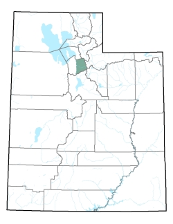
Policy area in green,
click on the map for more detail
Covering the eastern half of Salt Lake County
from T1N to T4S, this area includes the flows of City Creek, Red Butte Canyon,
Emigration Canyon, Parley's Creek, Mill Creek, and Big and Little Cottonwood Creeks, all of which drain
into the Jordan River and eventually the Great Salt Lake. The area is bordered
on the north by Davis County, on the west by the western part of the Jordan
River drainage, on the south by the Utah Lake drainage, and on the east by
the Weber River drainage. The highest point in the area is 11,489 foot Twin
Peaks, while the lowest is the surface of the Great Salt Lake at about 4,200
feet, giving a total relief of about 7,290 feet.
Click anywhere on map to close
|