AREA 71 - ESCALANTE VALLEYUpdated:ĀJanuary 16, 2013Changes from prior policy text in red text. |
|
|
MANAGEMENT Water rights in this area were compiled into a Proposed Determination of Water Rights in 1947. This publication was superceded by the subsequent completion of five books in the Escalante Valley Division of the Beaver River/Escalante Valley Adjudication filed with the Fifth Judicial District Court as follows: Enterprise area in 1963, Beryl area in 1964, Milford area in 1964, Millard County area in 1964, and a supplemental book in 1965. A pre-trial order was issued in 1970. Two state-administered distribution system cover this area; the Beryl-Enterprise Distribution System is administered by the Beryl-Enterprise Commissioner, while the Milford Distribution System is administered by the Milford Area Commissioner. Click here to see statistics for this area. SOURCES Surface Water: Surface waters of the area are considered to be fully appropriated. New surface diversions and uses must be accomplished by change applications based on valid existing water rights. Fixed-time projects involving surface waters must be accomplished by temporary change applications on valid existing water rights, which require annual renewal. Change applications involving a transfer between surface and ground-water sources are generally not allowed. Ground Water: Most of the area is closed to new appropriations with the exception of the northernmost portion. New ground-water diversions and uses must be accomplished by change applications based on valid existing water rights. Fixed-time projects involving ground water must be accomplished by temporary change applications on valid existing water rights, which require annual renewal. For ground-water administration, the area has been divided into three districts, each with some unique policies. Click here to see a map of these policy areas (PDF format). On December 21, 2012 a groundwater management plan was implemented for the Beryl Enterprise Area that modified the policies and boundaries for the districts.
GROUNDWATER MANAGEMENT PLANS
GENERAL Applications are advertised in the Millard County Chronicle, the Beaver Press, or the Spectrum/Daily News, depending on their location. Filing that may involve the diversion of water in Utah for use in Nevada (export) would be subject to the special criteria the statutes require for such projects. The general irrigation diversion duty for this area, which the State Engineer uses for evaluation purposes, is 4.0 acre-feet per acre per year. The consumptive use requirement is determined from the publication Consumptive Use of Irrigated Crops in Utah, Research Report 145, Utah State University, 1994, unless the applicant submits other data for consideration. This area is administered by the Southwest Regional Office in Cedar City. Other Requirements The Water Right applicant is strongly cautioned that other permits may be required before any physical development of a project can begin and it is the responsibility of the applicant to determine the applicability of and acquisition of such permits. In order to avoid delays and ensure that Water Right approvals conform to applicable local ordinances, applicants should contact local governmental entities in advance to determine what ordinances are in place that affect the proposed project and to make sure that Water Right filings conform to those ordinances. The approval of a Water Right application does not imply any approval of a project by any other governmental entity. Approval of the project proposed in the Water Right application should be obtained from local governmental entities as necessary to implement a project. REFERENCES Technical Publication No. 6; Ground Water in the Escalante Valley, Beaver, Iron, and Millard Counties, Utah; Utah State Engineer's 27th Biennial Report; 1950. (Out of print) Technical Publication No. 13; Ground-Water Resources of Selected Basins in Southwestern Utah; Utah State Engineer; 1966. Technical Publication No. 43; Water Resources of the Milford Area, Utah, with emphasis on Ground Water; Utah Department of Natural Resources; 1974. Technical Publication No. 73; Hydrology of the Beryl- Enterprise Area, Escalante Desert, Utah, with emphasis on Ground Water; Utah Department of Natural Resources; 1982. Technical Publication No. 109, Water Budget and Simulation of One- dimensional unsaturated flow for a flood- and sprinkler-irrigated field near Milford, Utah; Utah Department of Natural Resources; 1995. Basic Data Report No. 6; Groundwater Data, Beaver, Escalante, Cedar City, and Parowan Valleys, Parts of Washington, Iron, Beaver, and Millard Counties, Utah; Utah State Engineer; 1963. (Out of print) Basic Data Report No. 35; Groundwater Data for the Beryl-Enterprise Area, Escalante Desert, Utah; Utah Department of Natural Resources; 1981. Basic Data Report No. 43; Selected Test-Well Data from the MX Missile Siting Study, Tooele, Juab, Millard, Beaver, and Iron Counties, Utah; 1985. U.S. Geological Survey Professional Paper 1409-G; Ground-Water Hydrology and Simulated Effects of Development in the Milford Area, an Arid Basin in Southwestern Utah; U. S. Geological Survey; 1998. Water-Resources Investigative Report 95-4173, Simulated Effects of Proposed Ground-Water Pumping in 17 Basins in East-Central and Southern Nevada; U.S. Geological Survey; 1995 (viewing these USGS documents requires the DjVu browser plugin available from LizardTech) USGS Scientific Investigations Report 2014-5213, Steady-State Numerical Groundwater Flow Model of the Great Basin Carbonate and Alluvial Aquifer System; 2014. USGS Scientific Investigations Report 2017-5072, Groundwater Model of the Great Basin Carbonate and Alluvial Aquifer System Version 3.0: Incorporating Revisions in Southwestern Utah and East Central Nevada; 2017. MODELING Beryl-Enterprise Ground-Water Flow Model; 1982. Milford Area Ground-Water Flow Model; 1998. Regional Ground-Water Flow, Carbonate-Rock Province, Nevada, Utah, and Adjacent States; USGS Open-File Reports 93-170 and 93-420; 1993. PREVIOUS PAGE UPDATES |
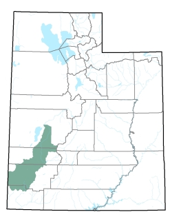
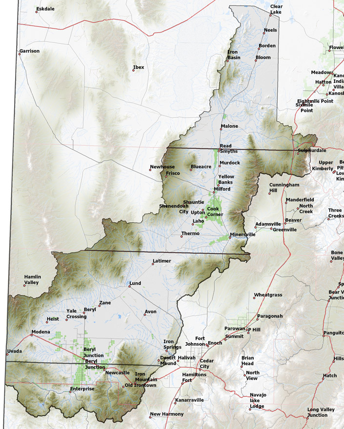
Policy area in green,
click on the map for more detail DESCRIPTION Extending northward from the 7,680 foot Bull Valley Mountains and the 10,238 foot Pine Valley Mountains in northern Washington County (T38S) through western Iron and Beaver Counties into south-central Millard County (T19S), this drainage basin includes the watersheds of Shoal Creek, Pinto Creek, and Little Pinto Creeks in the south, and the watershed of Cove Creek and the Beaver River below Minersville (Rocky Ford) Reservoir to the Sevier Desert in the north. The southwestern end of the valley borders Nevada. It is bounded on the west by the 9,660 foot Needle Range and the 7,231 foot Cricket Mountains, and on the east by the 7,226 foot Black Mountains, the 9,578 foot Mineral Mountains, and the Black Rock Desert. The northern end opens into the Sevier Desert. The lowest point is where the Beaver River leaves the area at 4,560 feet, giving the basin a total relief of about 5,700 feet. |
|
|
|