AREA 85 - KANAB and JOHNSON CREEKSUpdated:ĀApril 17, 2011 |
|
|
MANAGEMENT There are three court decrees in this area, all dealing with the surface waters of Johnson Wash. They are the 1896 McCarty Decree, the 1909 Chidester Decree, and the 1926 Bates Decree. Water rights in this area were compiled into a Proposed Determination of Water Rights in 1974. No pre-trial order has been issued. Because this area is tributary to the Colorado River, the provisions of the 1922 Colorado River Compact and the 1944 Mexican Treaty apply. However, there are no interstate compacts which specifically apportion the waters of this area. In 1999, the State Engineer issued an Interim Policy for Evaluating Change Applications in the Johnson Canyon Drainage which details the criteria which will be used to evaluate changes in water rights, especially those proposing to convert decreed surface water rights to underground rights. There are no state-administered water distribution systems in this area. Click here to see statistics for this area. SOURCES Surface and Ground Water - Surface and underground waters of the area are considered to be fully appropriated. New diversions and uses must be accomplished by change applications based on valid existing water rights. Fixed-time projects must be accomplished by temporary change applications on valid existing water rights, which require annual renewal. Change applications proposing a change from surface to underground sources, or vice versa, will be critically reviewed to assure hydrologic connection, that there are no enlargements of the underlying right(s), and that there will be no impairment of other rights. The State Engineer allows that there may be limited unappropriated water available from bedrock aquifers in isolated locations. Applications proposing to appropriate such waters will be reviewed on their own merits. GENERAL Applications are advertised in the Southern Utah News. Filings that may involve the diversion of water in Utah for use in Arizona (export) would be subject to the special criteria the statutes require for such projects. The general irrigation diversion duty for this area, which the State Engineer uses for evaluation purposes, is 5.0 acre-feet per acre per year. The consumptive use requirement is determined from the publication Consumptive Use of Irrigated Crops in Utah, Research Report 145, Utah State University, 1994, unless the applicant submits other data for consideration. This area is administered by the Southwest Regional Office in Cedar City. Other Requirements The Water Right applicant is strongly cautioned that other permits may be required before any physical development of a project can begin and it is the responsibility of the applicant to determine the applicability of and acquisition of such permits. In order to avoid delays and ensure that Water Right approvals conform to applicable local ordinances, applicants should contact local governmental entities in advance to determine what ordinances are in place that affect the proposed project and to make sure that Water Right filings conform to those ordinances. The approval of a Water Right application does not imply any approval of a project by any other governmental entity. Approval of the project proposed in the Water Right application should be obtained from local governmental entities as necessary to implement a project. REFERENCES Technical Publication No. 15; Water from Bedrock in the Colorado Plateau of Utah; Utah State Engineer; 1966. Technical Publication No. 70; Groundwater Conditions in the Upper Virgin river and Kanab Creek Basins Areas, Utah, with Emphasis on the Navajo Sandstone; Utah Department of Natural Resources; 1981. MODELING Navajo Sandstone Ground-Water Flow Model; 1992. PREVIOUS PAGE UPDATES None available. |
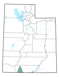
Policy area in green,
click on the map for more detail DESCRIPTION Located in the western section of Kane County, this area extends from T38S to T44S, where it meets Arizona. It is bounded on the west by the Virgin River drainage and on the east by the Paria River drainage. The highest point is at about 9,350 feet, along the divide with the Sevier River drainage, the lowest point is where Kanab Creek leaves the state at 4,800 feet, giving the basin a total relief of about 4,550 feet. |
|
|
|
