
The original Bear River Compact of 1958 and the Amended Bear River Compact
of 1980, in conjunction with the Bylaws of the Bear River Compact Commission,
various court decrees, and the laws of the States of Wyoming, Idaho, and
Utah, establish the framework under which the waters of the Bear River
are divided. This framework regulates how the waters of the Bear River
are distributed to water users in Wyoming, Idaho, and Utah as the River
threads its way in and out of state lines, first in a northerly direction,
then with a turn to the west and a reversal of directions to the south,
and eventually terminating in the Great Salt Lake.
Because of the River's sinuous path across state lines, interstate agreements
were necessary. The documentswhich compose the legal framework for division
of the river between the statesstand for themselves. However, behind those
formal documents is a history of intriguing stories, long negotiations,
and well-thought-out objectives and compromises. No one has been more involved
in the establishment of the framework under which the Bear River is now
managed between the three states than the author of this report, Wallace
N. Jibson.
Wallace N. Jibson, or as most of us know him--"Wally", has served the
water users and the three states with respect to Bear River regulation
for more than four decades. The Commission felt that it would be most important
to have Wally record for posterity his remembrances with respect to Compact
negotiations and administration and to further provide additional background
and insight into related issues.
The Commission appreciates Wally's longstanding service and further
appreciates the history which he has written. This document does not constitute
a formal history of the Bear River Compact Commission nor was it intended
to do so. Instead, it represents an extended history of water use, water
negotiations and water distribution along the river as seen and remembered
by Wally.
Jack A. Barnett
Engineer-Manager
The Bear River Commission recognized the need of an unofficial record
of events and the personnel that were involved in the formulating and the
administration of the Bear River Compact and the Amended Bear River Compact.
This record spans some 45 years and involves a large number of Federal,
State, private, and local water officials from the three states in addition
to many grass-root water users who provided practical and valuable insight
into compact negotiations. The Commission provided funding and other assistance
in preparing the history, and members have been especially tolerant of
several delays beyond the initial time frame for completion.
The author is indebted to members of the Commission and others who reviewed
preliminary drafts and offered a number of suggestions, most of which have
been incorporated into the history. I especially appreciate the valuable
advice and direction of Jack A. Barnett, Bear River Commission Engineer-Manager,
and his secretary, Heidi S. Marciniak, who has typed, corrected, and retyped
draft after draft of the history. Special appreciation also to Jack for
making available his word processor, printer, and other office equipment.
Alan Robertson, Idaho Department of Water Resources, and others who
had served on the Technical Subcommittee of the negotiators for the Amended
Compact have been very helpful in providing background information. Quantities
included in the Amended Compact on storage allocations and depletion limitations
have been derived from their hydrologic analysis.
Wallace N. Jibson
(BY WALLACE N. JIBSON(1))
Naming of Bear River and Bear Lake
As rivers are measured, Bear River probably has only one distinction:
that of being the largest stream in North America whose waters do not reach
an ocean. But it is also a stream of geographic and political complexity
as it enters the States of Wyoming, Utah, and Idaho a total of five times
in its 500-mile circuitous course from Utah's Uinta Mountains to Utah's
Great Salt Lake--only 90 miles from headwaters to mouth.
A brief historical background may be of interest beginning with the
record of the first white trappers to enter and explore Bear River basin.
First to come were fur trappers from Jacob Astor's British-owned American
Fur Company in 1812 who gave the name of their leader, Miller, to the Bear
River. Then in 1818 trappers of the French and British Northwest Fur Company
entered the basin by way of Soda Springs, and Michel Bourdon attached today's
name of Bear River because of the many bears encountered along the river.
Bourdon traveled downstream and gave the name Little Bear River (also called
Bourdon River) to what is now the Logan River. Part of the group moved
upstream to Bear Lake Valley and gave the name Black Bear's Lake to the
Lake.
Captain Weber and other Americans evidently "discovered" Bear Lake in
1824 and called it Weaver's Lake. The lake had other names--Little Lake,
Sweet Water Lake, etc. But the British "Bear Lake,"--shortened from Black
Bears Lake--prevailed. Smiths Fork was named for Jedediah Smith who named
Cache Valley and Blacksmith Fork.(2) Hayden
Fork of the Bear River and King's Peak, Utah's highest, were named for
early investigators with the U.S. Geological Survey.
Irrigation Development and Early Studies
Mormon pioneers in their trek to Utah crossed the Bear River upstream
from Evanston. Wes Myers, Bear River Commissioner from Wyoming, tells of
his grandfather going on to Salt Lake, where he operated a small business
for a year or two, but he returned to the Bear River and eventually started
a ranching operation. Today, several miles of river basin are part of the
Myers Ranch. Myers' irrigation canal, with an 1862 water right, claims
the earliest water right priority on the Bear River and also in the State
of Wyoming.
Somewhat surprising is the extent of irrigation development--and potential
disputes--that had taken place before statehood, which was granted in 1890
to Idaho and Wyoming and in 1896 to Utah. G.K. Gilbert included a brief
study of the Utah part of the basin in a report by Major J.W. Powell to
the Congress in 1878. A couple statements of interest were to the effect
that sufficient water was available in the river to irrigate about 90 square
miles (57,600 acres) "under ditch" in the Woodruff-Randolph area; but if
the necessary waters were appropriated, too little would remain for the
use of lands bordering the river in Wyoming. These lands would have equal
claim, and a "proper" distribution would allocate the supply to the best
selection of land in the two Territories. Also, ". . . where the river
next enters Utah, it has acquired so great a volume that it is impractical
to make use of its entire amount."
In that 1878 report, Major Powell asked the Congress for laws governing
priorities and beneficial use of water to be included in the homestead
laws. But the Congress took no action, leaving policy to the States and
Territories. Again in 1889 in the Eleventh Annual Report of the U.S. Geological
Survey, Major Powell discussed the river system including plans to divert
up to 2,000 cubic feet per second (cfs) of water where the river leaves
Cache Valley. He then posed these questions: "In times of scarcity, who
is to apportion this water? What protection do present users enjoy against
the stronger and richer canal companies?" Further, ". . the project and
notices of appropriation caused uneasiness among individuals and communities,
especially in Idaho, for fear of a contest regarding water . . . ."
Major Powell was largely responsible for the establishment of the U.S.
Geological Survey (USGS) in 1879 and became its second director in 1881.
His efforts were in good part responsible for the enactment of the Irrigation
Survey which was placed under the direction of the USGS. A few months later
the science of stream gaging was developed, and Bear River near Collinston
gaging station was established in July 1889 to be among the first gaging
stations in the country. The Irrigation Survey was terminated in 1890,
but not the stream gaging program that continues today under the USGS.
The feasibility of diverting water from Bear River into Bear Lake was
discussed in Department of Agriculture Bulletin No. 70 in 1898. An estimated
400,000 acre-feet of usable storage could be provided by raising the "turnpike"
or natural causeway in several places to provide for a 5-foot range in
stage. Priorities across state lines and a common river administration
were advocated in this report--possibly an implication of Federal administration
in this interstate stream. A further quote, "A great many of the irrigators
who are taking water from this stream and experiencing this unsatisfactory
condition of affairs have called for a remedy, and have urged a division
and adjudication of the waters of the entire stream." The writers also
noted the difference in character of rights as between states and stated
further, ". . . claims of appropriation could not be taken as a basis for
the equitable division of its water." This was to be the subject of many
discussions and disagreements some 50 years down the road.
George Swendsen, Utah Agricultural College, working for the Federal
Reclamation Service, in 1902-1903 examined Bear Lake as a possible storage
reservoir for irrigation and made note of two private projects then under
development. Telluride Power Company was constructing a channel (Dingle
Inlet Canal) from Bear River to Mud Lake. The Utah Sugar Company was constructing
a channel from Mud Lake to the Bear River. Little progress was being made
on either project.
We see from these early reports that irrigation was but a few years
old when disputes arose on water rights. Territorial rights make up most
of the rights in the basin. The United States was the sovereign and confirmed
the law of appropriation which existed by local customs, laws, and court
decisions in the three territories. This appropriation doctrine was confirmed
later by the constitutions of the three States, and rights continued to
be acquired.
Utah Power and Light Company(3)
and Bear Lake
Utah Power and Light Company (UP&L) was organized in 1912, consolidating
Telluride Power Company with many other predecessor companies. UP&L
continued the Bear River to Bear Lake project started by Telluride and
the Utah Sugar Company, and completed the project in 1918. In the period
from about 1907 to 1916, the Dingle (Telluride) canal, diverting upstream
from the present Rainbow Inlet Canal, intercepted a number of tributary
sloughs. According to George Swendsen (1916) the canal diverted relatively
significant amounts of water into slough areas (Mud Lake), raised the water
surface, and overflowed into the Bear Lake natural outlet channel.
In December 1912, UP&L and Utah-Idaho Sugar Company entered into
a perpetual agreement whereby the Sugar Company conveyed to UP&L all
property in the vicinity of the present Cutler Dam including the diversion
dam, canal headworks, existing power plant (Wheelon), transmission lines,
and other properties and land. Also conveyed were all approved or pending
water rights for power owned by the Sugar Company.
UP&L in return agreed to deliver a continuous flow of 900 cfs between
May 1 and October 31 and 150 cfs between November 1 and the following April
30 each year for irrigation, municipal, and other purposes. To the extent
that natural flow of the Bear River would not meet this demand, UP&L
agreed to make up the difference with stored water. The UP&L also agreed
to maintain, operate, and repair the dam, canals, and diverting works for
which the Sugar Company in partial consideration would pay $4,000 annually.
Somewhat surprising is that the contract became effective in 1913, five years before completion of the Bear Lake project. But in this period, the Lake was converted into a storage reservoir by construction of inlet and outlet canals and a pumping plant (Lifton) near the center of the north shore in a natural causeway that was built up by wave action. The pumps lift water from the Lake into the outlet canal where it returns to Bear River at a point just west of Montpelier, Idaho. Five hydropower plants--Soda, Grace, Cove, Oneida, and Cutler--were built and completed by 1927. This is today, in 1990, the most important single development affecting Bear River water and placed the Bear Lake project in the middle of deliberations toward a long-negotiated Bear River Compact.
Water Rights, Dietrich Decree
Water rights in Bear River basin are evidenced under state law by court
decrees, water applications, or water users' claims in pending suits for
adjudication. Rights in Summit, Rich, and Cache Counties, Utah recently
have been adjudicated in the courts. Earlier rights in Cache and Box Elder
Counties were decreed in the "Kimball Decree" in 1922. Wyoming water rights
are tabulated in a document entitled Tabulation of Adjudicated Water
Rights of the State of Wyoming, Water Division Number Four. Updated
versions are published at 3, 4, and 5-year intervals; also, unadjudicated
rights in good standing are published.
Idaho water rights above Stewart Dam are decreed in a State District
Court case entitled "Preston-Montpelier Irrigation Company v. Dingle Irrigation
Co. et al.," and from Stewart Dam (see map on page ii) to the Utah State
line in a Federal District Court decree known as the "Dietrich Decree"
filed July 14, 1920. This decree granted a right to Utah Power and Light
to divert 5,500 cfs of Bear River water into Bear Lake; thereafter to be
released at UP&L's pleasure ". . . for the generation of electric power,
and for such irrigation or other beneficial purposes, recognized by law,
as the plaintiff (UP&L) may devote or dedicate said released stored
water, by use, sale, rental, or otherwise" (quotation from the decree).
Noteworthy is that UP&L's storage right in Bear Lake is the only
right to store water in the Lake. The "Irrigation Reserve" (discussed later)
in the Compact restricts only the release of stored water under certain
conditions. Noted also is that the Dietrich Decree specifies no restrictions
relative to lake operating levels, maximum or minimum water surface elevations,
or total quantities to be stored.
The first capacity table for usable contents of Bear Lake that I have
seen was prepared by A.B. Purton, USGS, in 1942 from a 1922 UP&L contour
map. Maximum usable capacity (1,421,000 acre-feet) is shown at a surface
elevation of 5,923.65 feet (UP&L Datum) further described by Mr. Purton
as "top of outlet works". This elevation has been considered as the upper
limit of storage with existing facilities, though the concrete overflow
wall or sill is somewhat higher according to a USGS benchmark on the sill.
I have determined that the published elevation of 5,924 feet, when adjusted,
shown on the 1912 USGS quadrangle map (before influence by man on Bear
Lake surface elevations), coincides with the currently accepted upper limit
of storage. The published map elevation, 5,924 feet, was rounded from 5,924.1
feet, based on an average of three elevation determinations in 1909 along
the east side of the Lake. Datum corrections were made in mean sea level
in 1912, 1929, and 1947 totalling a plus 2.25 feet, which, when adjusted
to UP&L datum (-2.75 ft), equals 5,923.60 feet. Waterfront property
around the lake shoreline occasionally sustains damage at higher lake elevations
from wave action and wind-caused ice encroachment. Owners tend to blame
operation of the lake as a storage reservoir for this problem, but evidently
it would have taken place under pristine conditions.
The accepted minimum elevation is the bottom of the pump draft tubes
or lower limit of existing pumps and is at elevation 5,902.00 feet. This
low point or zero usable content point was reached November 9, 1935. Reservoir
range then is 21.65 feet, with usable capacity of 1,421,000 acre-feet.
The decreed right to store 5,500 cfs with two priority dates of 1911
and 1912 caused considerable controversy during interstate negotiations
toward a compact. Bear River flow reaching Stewart Dam, the point of diversion
to Bear Lake, has not in the 68-year period of record exceeded 5,000 cfs
(maximum of record, 5,000 cfs in 1984). Rights above Stewart Dam with later
dated priorities than 1911 and 1912 might have been subordinate to the
Bear Lake storage right. However, only water users in Cache and Box Elder
Counties, Utah, and in Idaho were joined as defendants in the Dietrich
Decree. Water users in Wyoming and in Rich and Summit Counties in Utah
were not parties to the suit and therefore not bound by the decree. Distribution
in Idaho has been in accordance with the decree.
Supreme Court Decisions
The Supreme Court of the United States has decided a number of cases
between states on an interstate stream where the appropriation doctrine
has been adopted in both states. A case involved Wyoming v. Colorado on
waters of the Laramie River (259 US.419) is one in which the court held
that one state must recognize another state's priorities under the doctrine
of appropriation. In a later case, Nebraska v. Wyoming, 325 U.S. 589 decided
in 1945, the court referred back to the Laramie River case but concluded
that strict adherence to the priority rule may not be possible; one state
is not entitled to more than its equitable share of the benefits of an
interstate stream.
Water Right Controversy
Each of the principles mentioned above as recognized by the court applies
to the Bear Lake storage right, so precedent can be argued either way.
In any event, the likelihood of a court injunction resulted in a relatively
small amount of storage development in the basin above Bear Lake from 1920
until 1958. The issue was, Would upstream storage be subordinated by the
Bear Lake storage right? Wyoming had granted rights for about a dozen small
reservoirs that were constructed prior to the Compact with a combined capacity
of about 2,000 acre-feet, and with later-dated priorities than the Bear
Lake right. Utah users had constructed the Little Creek or Randolph Creek
Reservoir, capacity 614 acre-feet, under a 1920 priority. The original
Compact recognizes as existing in Idaho only one reservoir on Sheep Creek
and three in Wood Canyon (Thomas Fork), with total capacity of 324 acre-feet.
Priority dates were not furnished at the time of a 1955 survey by the author.
Bear Lake storage right for years was a sore spot to users in the upper
basin. But, on the other side of the coin, distribution of natural flow
in the 1931-1935 drouth period created serious problems for Idaho users,
and to a lesser extent for Rich County users in Utah. In each instance,
Wyoming has the "hiority" if not the priority, and has the first chance
to divert Bear River water from the Uinta watershed and to divert Smiths
Fork water ahead of Idaho in the central part of the basin. The 1931-1935
period is the driest consecutive five years in the 65-year period, 1922-1986
(water supply to Bear Lake in the 5-year period, 1987-1991, was less than
in 1931-1935). Irrigators dependent on Bear Lake for a partial or full
supply of water fared better during this period because of improved runoff
in 1932 and 1933 that replenished the dwindling holdover in Bear Lake.
This holdover was totally depleted by November 1935.
Users above Bear Lake however, experiencing six below-average years
(1930-1935) of runoff, had no storage as a backup and had moderate to severe
deficiencies through the entire period. Aggravated by inequitable sharing
between states, the situation prompted Idaho users to vow that relief must
come through the courts or by an interstate compact.
Early Compact Negotiations
Friction among upper basin users over Bear Lake storage rights and lack
of interstate control over irrigation season natural flow, together with
the U.S. Bureau of Reclamation's concern for future Reclamation project
development, brought about negotiations toward an interstate compact.
A series of informal meetings began in March 1943 in which the three
State Engineers, with USGS and Reclamation personnel, laid the groundwork
for future more formal negotiations. Ed Watson, Utah State Engineer, was
chosen as Chairman of the group. E. J. Skeen, Assistant to the Attorney
General in Utah, was chosen as Secretary. Idaho was represented by James
Spofford (succeeded by Mark Kulp), State Reclamation Engineer; Fred Cooper,
Grace; and E. J. Baird, Soda Springs. Wyoming was represented by L.C. Bishop,
State Engineer; David Miller, Rock Springs; and Emil Gradert, Robertson.
Utah was represented by Ed Watson, State Engineer; and E. J. Skeen. UP&L
was represented by F. Gerald Irvine, Attorney, and E. G. Thorum, Hydrologist.
First approved was a rather comprehensive streamflow data collection
program which included all tributary flow records in addition to expanding
existing gaging sites on the main stem. Initially, this was a joint effort
of USGS and Reclamation, with financial support from the states and local
users. Then a project office in Logan was established by the USGS with
W.V. (Vaughn) Iorns in charge, who not only directed the streamflow program
but was given permission by the USGS to assist the States in an engineering
and advisory capacity.
The Congress, as required by the Constitution, granted consent July
24, 1946, to the States to negotiate and enter into a compact (HR 4870,
12-3-4S), and E. O. Larson, Regional Director of Reclamation, was appointed
as the Federal Representative by President Truman on August 6, 1946. The
authorizing legislation gave considerable latitude to the States to use
any basis they chose in negotiations.
Early negotiations toward administering the entire river on a priority
basis without regard to state lines met with much resistance which threatened
to halt further negotiations. Also, water in the system essentially was
fully appropriated which meant that on a priority basis, storage allowance
above Bear Lake was out of the question. Further, strict priority distribution
between Wyoming and Idaho in the Central Division would create such serious
deficiencies in supply for 10,000 acres in the Smiths Fork drainage that
in many years total crop failures would result. Thus, recognition by the
Supreme Court (Nebraska v. Wyoming, 325 U.S. 589, 1945) (page 8) that strict
adherence to the priority rule may not be feasible became very pertinent
to continuing efforts to negotiate a compact.
Storage Allocation Above Bear Lake
Two concepts then became evident fairly early in negotiations. First,
an annual storage allocation to users above Stewart Dam would be granted
that would not be junior to the Bear Lake storage rights. Second, division
of natural flow water between Wyoming and Utah in the Upper Division and
between Wyoming and Idaho in the Central Division would be based on respective
irrigated acreages.
Neither concept was readily accepted by UP&L or Idaho negotiators.
We should keep in mind that Bear River hydropower was then the lifeblood
of UP&L, whose five hydropower plants below Bear Lake (115,000 kw)
were generating an estimated 75 percent of its total power production as
compared to less than 5 percent in 1990. Increased usage or depletion above
Bear Lake was a matter of serious concern to UP&L representatives on
the Negotiating Committee. Large quantities of water released from Bear
Lake solely for power production in the 1924-1927 period lowered the Lake
about 14 feet to approximately 5,909 elevation and set the stage for the
Lake being depleted to zero usable content by November 1935.
Bear Lake had become the lifeblood also to thousands of irrigated acres
in Idaho and lower Utah. Frequently the question is asked, "Why did the
initial Compact fail to divide direct flow and future developable water
between States in the Lower Division?" The answer primarily is that even
though power production may have had equal or first priority over irrigation
in the first years of Bear Lake operation, stored water from the Lake has
been adequate each year (except 1934) to fill supplemental irrigation requirements
for more than 150,000 acres in Idaho and Utah. Essentially, because of
Bear Lake, there was no controversy between Idaho and Utah users, and the
negotiators had all the controversy they needed in the upper basin. The
Compact did, however, recognize priorities of Utah users against diversions
with junior priorities in Idaho.
About eight unofficial meetings of negotiators had been held between
March 5, 1943, and June 23, 1948, when the first official meeting was held
at Jackson with E. O. Larson conducting as Federal Representative and Chairman.
A second meeting at Preston was held December 13 and 14, 1948. The Negotiating
Committee included Mark Kulp, Fred Cooper, and William Hunter for Idaho;
Clark Bishop, David Miller, and Reed Dayton for Wyoming; and Ed Watson,
L. B. Johnson, and Orson Christensen for Utah. E. J. Skeen continued as
Secretary to the Commission. Analytical work, including the writing of
a tentative compact, had been done by Vaughn Iorns, USGS, with some assistance
from Lesher Wing, Federal Power Commission. E. K. Thomas, Reclamation,
analyzed future storage development potential for the negotiators. Engineering
and legal committees were appointed.
Two years went by before the next meeting of the Commission because
of critical attacks on a compact draft presented at Preston in which a
storage allocation above Bear Lake was not included. This was a low point
in negotiations, with serious doubts that agreement would ever be reached.
I attended the Preston meeting as an understudy of Mr. Iorns, and after
hearing him assailed from all sides, considered asking for a transfer--preferably
to Kansas. The tempo picked up after 1950 with two or three meetings each
year, until final approval of a compact by the States on February 4, 1955.
Suggested allocations for upstream storage ranged from "zero," proposed
by Idaho, to 150,000 acre-feet annually requested by Wyoming. Many studies,
many proposals and counter-proposals, and considerable "horse-trading"
took place in the 5-year period before settling on an allocation of 36,500
annual acre-feet, including 1,000 acre-feet to be stored on Thomas Fork
for use in Idaho. Actually, the allocation had more basis than just negotiation.
Engineering Committee studies analyzed supplemental needs in each state
section based on acceptable patterns of diversion, consumptive use, headgate
requirements, effects of compact regulation on future needs, and other
pertinent analysis. The Committee also investigated existing reservoir
sites and projected water supplies and shortages at each site.
Thomas Fork Controversy
The Thomas Fork allocation became the subject of controversy and held
up approval of the Compact by one year in the Congress. An Engineering
Committee study in May 1953 looked at storage requirements and storable
supplies above Bear Lake in which Thomas Fork irrigated land (Idaho) showed
a supplemental requirement of 9,000 acre-feet. A reservoir site in Wyoming,
with available supply could take care of most of this need.
Thomas Fork was not discussed until the second meeting following the
study, December 2, 1954, when George D. Clyde, Utah commissioner, questioned
the appropriateness of considering this Idaho tributary for a storage allocation,
the contention being that it was an Idaho problem and should not be part
of an interstate compact. Even so, Idaho commissioner Fred Cooper suggested
an allocation of 1,000 acre-feet. To me this was a token amount that would
accomplish nothing and would create a situation among Thomas Fork users
like dividing one bone among ten dogs. According to Mark Kulp, Idaho Reclamation
Engineer, the allocation was based on his recommendation several years
earlier in connection with WPA (Works Progress Administration) funding
for storage development.(4)
Representatives from Thomas Fork were not present at the December meeting,
nor did they attend until two meetings later on January 12, 1955, when
the Compact was in the final stages of approval. They protested the allocation,
citing our study showing the need for 9,000 acre-feet. During a recess,
I talked with Mr. Linford and Mr. Walter, representing Thomas Fork users,
and suggested that they consider withdrawing the inadequate allocation
and negotiate outside the Compact with UP&L and Idaho officials. Their
answer: "No. We will accept the 1,000 acre-feet as a `foot in the door'
situation and negotiate later."
Much to our surprise, Linford and Walter took their grievance to Congresswoman
Gracie Pfost and convinced her that negotiating meetings had not been publicized,
that UP&L was depriving users of water rights, and that Thomas Fork
had been ignored and then suddenly Thomas Fork became part of the Compact.
These claims were false, but Congresswoman Pfost delayed action in the
house from 1957 to 1958 when approval was given. Late filing in the Wyoming
Legislature delayed action from 1955 until 1957, so three years passed
from Commission signing in 1955 until Presidential approval on March 17,
1958.
Bear Lake Irrigation Reserve
While on the subject of storage allocation, another important part of
the Compact, the irrigation reserve, should be explained, especially in
view of recent arguments and misunderstanding on the part of some Utah
users in the lower basin.
One of the difficulties in formulating an interstate compact on Bear
River was the question of allowing additional development of irrigation
reservoirs above Bear Lake without the decreasing water supply available
to Bear Lake adversely affecting users in Idaho and Utah who are dependent
on the Lake for part or all of their irrigation supply. The additional
storage rights above Bear Lake to be of any value could not be subject
to the earlier priority of UP&L rights to divert water to the Lake;
therefore, additional storage development would decrease the flow available
for storage in Bear Lake. Irrigators in Idaho and Utah felt that they should
be assured of at least the same supply that had been available to them
in past years and particularly in the 5-year critical period (1931-1935)
when Bear Lake was pumped to its lowest level.
Obviously, the only way this assurance could be given would be to reduce
the use of Bear Lake water solely for the generation of power over the
amount used in prior years. This reduction in the use of stored water for
power production could be accomplished by selecting a water level in Bear
Lake below which water could not be released solely for the generation
of power. This level would be selected at such elevation that if basin
runoff were to occur again in precisely the same amounts as occurred in
the past, the lower users could be assured a supply equal to that of the
5-year critical period, even though 36,500 acre-feet of additional water
would be stored each year above Bear Lake.
Simulated lake operation studies indicated that, with some allowance
for return flow from the new storage, an elevation of 5,914.70 feet (UP&L
datum) would accomplish this purpose, and water below such elevation would
constitute an "irrigation reserve." Further, it was concluded that inasmuch
as the new storage allowed above Bear Lake would likely take several years
to develop, a number of irrigation reserve elevations should be selected
corresponding to 5,000 acre-feet increments of storage as it was developed.
This resulted in an elevation of 5,912.91 feet being selected as an irrigation
reserve level which would be applicable until the first 5,000 acre-feet
of storage was developed. Thereafter, the elevation would be raised in
accordance with the table given in Article V of the Compact.
By October 1970, 30,883 acre-feet of new storage had been developed
above Bear Lake, so the irrigation reserve elevation was raised to 5,914.61
feet (active storage: 794,000 acre-feet) corresponding to the storage block
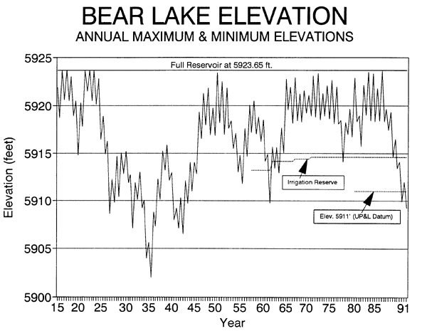
of 30,000 acre-feet. It remains at this level in 1990. The Lake was below
the reserve elevation for periods in the sixties, winter period in 1977-1978,
and since August 7, 1989. The following hydrograph allows the reader to
better understand the fluctuations of Bear Lake levels.
The provision prohibits release of Bear Lake stored water, except in
emergency, for the sole purpose of generating power when the Lake is below
the irrigation reserve elevation. Further, water from this reserve may
be used for hydropower as it is conveyed down the river channel for diversion
to irrigation. The provision does modify the basic storage right in the
Dietrich Decree as it pertains to the release and use of stored water.
The right of UP&L to divert Bear River water to storage in Bear Lake
remains as decreed. The Compact does not grant to irrigators the right
to store water in the Lake because of the irrigation reserve.
Natural Flow Allocation
Returning to the second major issue to be agreed upon--that of an equitable
division of natural flow above Bear Lake--we noted earlier that irrigated
acreage as a basis for allocation became the least controversial alternative
discussed. Even so, Idaho insisted through many sessions of deliberation
that interstate priorities should be given more weight. Some consideration
of priorities in this instance was tied to the initiating criteria of when
to begin interstate regulation (flow at Border and divertible flow) that
will be discussed later. Priority between Wyoming and Utah was not an issue.
Negotiators reached early agreement on several other concepts. For instance,
under a priority system seldom would tributaries, except Smiths Fork, be
regulated for benefit of main stem users. So Smiths Fork was the only tributary
included in allocations, and other tributary streamflow records were discontinued
after 1945. Also, a combination of irrigated acreage and relative priorities
would be controlling factors in allocation of natural flow. Interstate
priorities however became less important as negotiations continued.
Again based on priorities, the basin could be divided into three divisions
in which an upper division seldom if ever would be regulated for the benefit
of a downstream division. The Upper Division extends from the headwaters
down to and including diversions at Pixley Dam, about 11 miles upstream
from Cokeville. The Central Division comprises that portion of the basin
from Pixley Dam to and including Stewart Dam, the point of diversion to
Bear Lake. The Lower Division includes the basin below Stewart Dam including
Bear Lake and its peripheral tributaries.
To proceed and incorporate these concepts, the States furnished tabulations
of water rights and acreages. Reclamation and USGS personnel determined
irrigated acreage based on photography taken in about 1938 in which all
irrigated land was delineated and planimetered. These were used to check
and cross-reference acreages and water rights furnished by the States.
Reclamation personnel had done extensive field checking, and the measured
acreages were quite accurate.
Emphasis on direct flow allocation was directed principally to Wyoming
and Idaho Sections in the Central Division in analytical studies and negotiations.
This had been the area of controversy and greatest need for interstate
regulation. An extremely dry year, 1954, came along late in negotiations
and shifted the emphasis somewhat to the Upper Division where Wyoming again
had the "hiority" over Utah. Negotiators agreed that interstate allocation
should be provided for in both divisions.
The Upper Division includes four state sections: Upper Utah, a small
irrigated area in Summit County; Upper Wyoming, comprising about half of
the Division irrigated acreage above and below Evanston; Lower Utah, main
stem lands in Rich County accounting for about 40 percent of the Upper
Division; and Lower Wyoming, main stem lands from the state line below
Randolph to Pixley Dam upstream from Cokeville that includes about 10 percent
of the Division.
Acreage within each state, as planimetered on Reclamation land use maps,
was the starting point in arriving at compact percentage allocations. Hilliard
East Fork, Lannon, Lone Mountain, and Hilliard West Side canals divert
in Upper Utah for irrigation in Wyoming. Wyoming insisted on jurisdiction
over these canals, so 5,653 acres in these canals adjudicated by Utah was
added to Upper Wyoming acreage before computing the Compact allocation
of 49.3 percent. Acreage in Utah under Francis Lee and Bear River Canals
(2,151 acres) was adjudicated in Wyoming and included in Wyoming acreage
and allocation. Likewise, Lower Wyoming measured acreage was reduced by
1,884 acres in this section (B.Q. West Side Canal) adjudicated and allocated
in Lower Utah. Based on irrigated acreage as adjusted, Upper Utah received
0.6 percent of divertible flow (see next paragraph); Upper Wyoming, 49.3
percent; Lower Utah, 40.5 percent; and Lower Wyoming, 9.6 percent.
Similar thinking prevailed in the Central Division. Acreage in the Idaho
Section of the Central Division under the Cook Canal (2,476 acres) was
adjudicated by Wyoming and included in the Wyoming acreage and allocation.
Compact acreage for the Central Division then became: Wyoming 17,284 acres
(43 percent) and Idaho 23,278 acres (57 percent).
Divertible Flow
"Divertible flow" in the Upper and Central Divisions is defined as the
total water being diverted at any given time, plus the flow in cfs leaving
the division. In the Upper Division, this would include flow passing Pixley
Dam and in the Central Division, flow passing Stewart Dam. Criticism still
arises occasionally that the Rainbow Inlet Canal, diverting water at Stewart
Dam into Bear Lake (Mud Lake) is counted as a diversion when it irrigates
no acreage in the Central Division. For Compact purposes, the Rainbow Canal
diversion is in the same category as water leaving the division past Stewart
Dam. Ironically, the criticism has come from Wyoming users whose allocation
includes 43 percent of the discharge in the Rainbow Canal by definition
of divertible flow in the Central Division. Nevertheless, this is a natural
reaction by Wyoming users who, while being regulated, observe "surplus"
water in the Rainbow Canal rather than being diverted to Idaho land in
the Central Division. The primary reason for what may seem to be an inequity
is that Idaho meadow rights are cut off July 1 each year. Other diversions
being limited to adjudicated rights cannot utilize this meadow water which
remains in the system and reaches the Rainbow Canal. Total Idaho acreage
after July 1 is receiving far less water per acre than Wyoming acreage
except in dry years.
Assuming the Rainbow Inlet Canal did not exist, obviously the divertible
flow in the Central Division would not change, and Wyoming Section would
get the same allocation as today. Idaho diversions would still be administered
under state law, and unused water would be leaving the division. Diversion
into the Rainbow Inlet Canal during the irrigation season is highly significant
to Idaho users below Bear Lake because, by the Dietrich Decree, this flow
plus flow below Stewart Dam is the first measure of natural flow earmarked
for the Last Chance Canal Company in accordance with its priority.
Initiation of Water Emergency
When the divertible flow in the Upper Division, as defined on page 14,
is less than 1,250 cfs, a water emergency is in effect during the irrigation
season. Such an emergency in the Central Division is in effect when either
the divertible flow is less than 870 cfs or the flow passing the Bear River
at Border, Wyoming gaging station is less than 350 cfs. Water emergencies
terminate on September 30 (Amended Compact) each year unless the date is
changed by the Commission.
The flow rates that initiate water emergencies in the Upper and Central
Divisions were agreed upon after considerable discussion in a number of
meetings. Analysis of historical records showed that small changes in these
initiating flow rates did not significantly change the periods of regulation
in either division. To arrive at initiating flow rates (next paragraph),
which related to quantities available to fill basic rights in each of the
States, required a look at rates of allocation under state law. Wyoming
basic rights are allocated at the rate of 1 cfs for each 70 acres, with
a surplus right of double this amount when water is available; Summit and
Rich Counties in Utah were not yet adjudicated, but claims were based on
canal capacity with a maximum seasonal diversion of 3.0 acre-feet per acre.
(In dry years, no one is able to divert 3.0 acre-feet per acre, so the
wide range in diversion rates has caused some controversy within the state.)
Adjudication in Idaho varied according to "meadow" rights or "agricultural"
rights; so, the Commission used a basis of 1 cfs for 33 acres during the
flood water period and 1 cfs for 50 acres during the balance of the season.
The initiating rate in the Upper Division of 1,250 cfs of divertible
flow is the approximate total of rights in the division on a basis of 1
cfs for each 70 acres. In the Central Division, the divertible flow criterion
of 870 cfs was a negotiated takeoff from 810 cfs which are total rights
in the division based on 1 cfs for 50 acres. The flow passing Border of
350 cfs initially was 400 cfs, represented an approximate flow when there
is sufficient supply in the two states to divert 1 cfs for each 50 acres.
The final compact amounts of 350 cfs at Border or divertible flow of 870
cfs in average years occur within a few days of each other. In dry years,
divertible flow generally falls below 870 cfs first and initiates the emergency.
Final Negotiation and 1958 Compact
Intensive negotiations in a series of seven meetings, December 2, 1954,
to February 4, 1955, resulted in much compromise, threatened walkouts,
and apparent insurmountable differences. But, the old negotiators with
important newcomers, George D. Clyde assisted by Jay R. Bingham of Utah,
hammered out their differences and on February 4, 1955, signed a Bear River
Compact. E. J. Skeen, signing as Secretary to the Commission, played an
important role in negotiations not only as secretary but in taking the
lead in drafting the Compact and in including necessary provisions to get
approval of the Congress.
As we are now operating under an Amended Bear River Compact with different
signers, it is desirable for the record to list those signers of the initial
Compact. They were, for Idaho: Mark R. Kulp, Fred M. Cooper, and Melvin
Lauridsen; for Utah: George D. Clyde, Lorenzo Weidman, A. V. Smoot, Lawrence
B. Johnson, Alonzo Hopkin, E. M. Van Orden and Orson A. Christensen; and
for Wyoming: L. C. Bishop, H. T. Person, Howard B. Black, Emil C. Gradert,
and S. Reed Dayton. Signing for the United States was E. O. Larson, and
as Secretary, E. J. Skeen. President Dwight D. Eisenhower signed approving
legislation on March 17, 1958.
Two additional meetings of the Negotiating Committee were held following
the signing of the Compact by the states on February 4, 1955: one at Phoenix,
Arizona, on November 7, 1957; and the second at Salt Lake City on February
20, 1958. During these meetings, in addition to pursuing Congressional
approval of the Compact, contacts were made with USGS authorities in Washington
to get approval for the author to assist in the administration of the Compact.
This approval was granted with some limitations; namely, as a Federal employee,
I was not to be involved in actual regulation of diversions. Preservation
of the authority of the Commission and the States was to be of first importance.
The first official meeting of the newly organized Bear River Commission
was held April 5, 1958. Nominees for Federal Representative and Chairman
were made. Budget and Operations Committees were appointed. Bylaws were
approved in the second meeting on April 26, 1958, and Jay R. Bingham, who
had assisted George D. Clyde in negotiations, was appointed Secretary of
the Commission. In compliance with U.S. Geological Survey limitations and
the desire of the Commission with respect to Federal employees, Wallace
N. Jibson was first appointed Assistant Secretary and, after retirement
from Federal service, as Engineer-Manager. Utah commissioners were Jay
R. Bingham, Lawrence B. Johnson, and A. V. Smoot. Wyoming commissioners
were Earl Lloyd, S. Reed Dayton, and J. W. Myers. Idaho commissioners were
George N. Carter, Fred M. Cooper, and Melvin Lauridsen. E. O. Larson was
appointed as Federal Representative by President Eisenhower on June 16,
1958, and by Article III, Larson assumed the duties of Chairman. E. J.
Skeen was appointed Legal Advisor in Regular Meeting on November 28, 1960.
Direct flow allocation in the Compact has achieved in general an equitable
division of water between the States and has produced no particular surprises
from our early projections. Comparable diversion rates, published in biennial
reports, between Wyoming and Idaho in the Central Division, show effectiveness
of interstate regulation in dry years by the small spread in diversion
rate per acre. In average and better years, Wyoming has diverted on the
average 1.5 acre-feet per acre more than Idaho, but in dry years, only
0.3 acre-feet per acre more. Gravelly soils in Smiths Fork require a higher
rate of diversion but also yield higher return flows.
One direct-flow provision in the Compact that has been more significant
than probably anticipated is Article IV, A, e, regarding diversions in
the Upper Division. It permits unused allocation in a state section to
be available first for use in the other section of that state. This provision
was a latecomer in negotiations being proposed just a few weeks before
final approval of the Compact and adopted with only cursory studies of
its effect on interstate regulation.
Common practice has been to shut down irrigation in Lower Wyoming (B.Q.
and Pixley Dams) in the first few days in July, with a flush of water leaving
the division as water is released from behind B.Q. and Pixley Dams. This
practice has not changed appreciably since adoption of the Compact. The
effect on interstate allocations is to allow the 9.6 percent allocated
to Lower Wyoming to be available initially for use in Upper Wyoming. In
most years, the additional allocation comes at a time when Upper Wyoming's
diversion rate starts to exceed the basic allocation of 49.3 percent--not
because of an increased diversion rate, but because of rapid decline in
supply and divertible flow. The extra allocation quite often becomes the
difference between compliance and non-compliance with allocations for the
next two or three weeks until Utah shuts down irrigation for haying operation.
We may not argue the fairness of this provision, but doubt that anyone
expected it to be a factor in most years.
The transfer of unused allocation and the very rapid decline in supply
between the time that the divertible flow reaches 1,250 cfs and the time
lower sections in the Upper Division shut down irrigation for haying operation,
may lead some to question the value of direct-flow allocation in the Upper
Division.
Comparison of river operation in 1990 and prior to the Compact leaves
little question in my mind about the value of interstate allocation. For
instance, few canals in Upper Wyoming were equipped with adequate headgates
to effectively regulate the diversion, flow monitoring was not being done,
actual regulation in accordance with rights appeared to be minimal, and
very few canals were equipped with measuring flumes or weirs. In 1990,
all diversions can be and are being regulated in accordance with adjudicated
rights. Thanks to Wes Myers and others in his company who set an example,
many diversions are now equipped with Parshall flumes and all major diversions
are equipped with continuous recorders. Regulation in accordance with adjudication--without
direction of the Commission--for the most part has kept this section within
Compact allocation, even though allocation by practical necessity often
has been an "after the fact" determination.
Definitions and Explanation of Articles
General
Occasionally, questions arise on individual articles in the Compact
as to why certain definitions or recognition of rights were included and
others excluded. The following discussion of articles related to such questions
may be beneficial.
Article II
Article II lists definitions of certain terms used in the Compact. Paragraphs
18-24 define those tributaries of Bear River and Smiths Fork, diversions
from which are part of the divertible flow in the Central Division. Canals
defined in paragraphs 25-28 (Hilliard canals) are Utah diversions in Summit
County that irrigate only acreage in Wyoming. These canals have late-dated
Utah rights, and some have suggested that points of diversion were purposely
located in Utah to avoid Wyoming regulation. Wyoming State Engineer, L.
C. Bishop, made it known early in negotiations that he would not agree
to a compact that did not give him administrative supervision over these
canals. They are therefore included in Upper Wyoming Section diversions
and allocations.
Francis Lee Canal, paragraph 29, is one of two canals (also Bear River
Canal) diverting in Wyoming below Woodruff Narrows Reservoir and serving
some acreage in Wyoming, but most in Utah. Utah acreage under the Francis
Lee Canal had not been included in Wyoming adjudication, but was recognized
in the Compact. (See also Article X and "Tabulation of Wyoming Rights"
with Report 13, December 15, 1959, in Commission files.)
The Chapman Canal and Neponset Reservoir, paragraphs 30 and 31, were
also included in definitions because of a question in Wyoming adjudication
(see discussion of Article IX--Article X, Amended Compact). Article IV
again refers to interstate canals in the Upper Division as defined, and
specifies the state section to which their allocations of direct flow are
included. Also included in this article is the right to transfer unused
allocation as discussed earlier in this history. Interstate canals are
supplied from the state section allocation in which the point of diversion
is located, with the exception of the Hilliard canals diverting in Utah
for use in Wyoming as described earlier.
Article V
Article V (Article VI, Amended Compact) recognizes existing pre-compact
storage rights in constructed reservoirs above Stewart Dam. This recognition
is confined to aggregate acre-feet by states.
Legal and Engineering Committees in August 1951 requested that the USGS
conduct a field survey of existing reservoirs in the basin. This survey
would then be updated to the date of Compact approval so that existing
reservoirs could be confirmed in the Compact and segregated from new upstream
storage that would be allocated. Each state would furnish a listing by
name, source, location, priority, and adjudicated capacity. Non-adjudicated
reservoirs, if located, were to be included in the survey.
The author, assisted by Budd Robison of the USGS, conducted a field
reconnaissance in September and October of 1951 and summarized findings
in Report 22, Existing Irrigation Reservoirs in Bear River Basin,
dated November 28, 1951.
Considerable discussion in the negotiating group ranged from listing
each existing reservoir in the Compact to including the aggregate capacity
as a part of the new allocation. Significant is the approved final wording,
"Existing storage rights in reservoirs heretofore constructed . . ." (initial
Compact). Existing reservoirs without adjudication rights were not included
in the totals, but neither are they chargeable to new storage allocation.
In general, if the measured capacity in a reservoir was less than adjudicated,
the smaller quantity was used in the total. Likewise, if measured capacity
was greater than adjudicated, again the smaller quantity was used. The
only tabulation and record of surveys of these reservoirs is in the above-mentioned
Report 22 (Commission files).
Article IX
Article IX (Article X, Amended Compact) recognizes and confirms certain
rights on which questions were raised during negotiations. Adjudication
was pending on Summit County water user claims but on the Hilliard East
Fork Canal, there was no record of a claim being filed. The Wyoming State
Engineer furnished the irrigated acreage and date of priority. Recognized
primary right in the Hilliard East Fork Canal of 28.00 cfs was based on
the highest recorded daily flow, 1944-1950, and in general agreed with
Utah user claims based on canal capacity. (Flow rate exceeded 28 cfs in
1952, an extremely wet year.)
Amount of irrigated acreage in Utah under the Chapman Canal varied widely
from 14,276 acres adjudicated by Wyoming to 7,889 acres finally approved.
Consistency in what constitutes irrigated land for Compact allocation had
to be maintained in the three states. A general rule was to include willow
land and grass/brush land under canals where water was being applied. Another
was to include lands that had been irrigated but were temporarily out of
production, though not permanently abandoned. Extensive field checking
with state (Utah) hydrographic survey maps, together with aerial photos,
was carried out by Vaughn Iorns in 1951 with representatives of Deseret
Land and Livestock Company (DL&L). Wyoming adjudication rate of 1 cfs
for 70 acres was applied to Utah and Wyoming lands to arrive at the primary
rights as recognized.
Under state law, Wyoming could not issue a permit for Neponset Reservoir,
an out-of-state reservoir served by Chapman Canal. The state did, however,
issue an earlier certified letter stating that DL&L had complied with
all requirements for adjudication and such letter could be used for evidence
in future interstate negotiations.
Somewhat puzzling in view of this evidence was a rather heated discussion
between attorney Burton for DL&L and L. C. Bishop, Wyoming State Engineer,
on the Neponset right. It was, however, confirmed as a component part of
the irrigation right for Utah lands. The author made a survey of the Neponset
Reservoir spillway which apparently had washed out and was temporarily
replaced with sand bags. This survey, referenced to Bureau of Reclamation
bench marks, showed a sand bag capacity of 6,900 acre-feet, which was recognized
and confirmed in the Compact. The sandbag spillway has been replaced with
concrete, but no further survey was made by the Commission.
The maximum flow limitation of 134 cfs in the Chapman Canal was based
on the maximum flow which had been measured up to the date of the Compact.
The object of course was to prevent enlargement of the right, but the footnote
wording, "Under the right as herein confirmed . . ." does not prevent enlargement
of the canal capacity under a new right. Was this an oversight, or did
the negotiators assume that a late-dated priority would be of little practical
value either for storage in an enlarged reservoir or for supplemental direct
flow application?
Article X
The Francis Lee Canal right, a diversion in Wyoming for irrigation in
Wyoming and Utah, was recognized and confirmed in Article X to correct
an apparent oversight in Wyoming adjudication. The adjudication recognizes
the right to 154 acres in Wyoming but, though recognizing use in Utah,
did not adjudicate for 519 acres located in Utah.
First Years of Operation
Initiating the Compact in a dry cycle had advantages and disadvantages.
In the four-year period 1958-1961, supplies ranged from 80 percent of average
in 1958 down to 43 percent (Smiths Fork) in 1961. Interstate regulation
was badly needed and achieved an equitable division of natural flow during
these first years of operation, but also in 1961 (the driest since 1934
and 1940) we saw the futility of regulating in the Upper Division after
about mid June. With divertible flow decreasing rapidly in the 400-600
cfs range, most acreage in Lower Utah (Rich County) receives little if
any water from flat-gradient canals when discharging less than half capacity
under a falling head. Thus, little was gained from interstate regulation
during these periods.
A major difficulty in these first efforts to comply with interstate
allocation during these dry years was resistance to regulation by users
in the Central Division. Wyoming users had very little in-state regulation
prior to the Compact, but now they were faced with very severe regulation
for the benefit of another state. The Operations Committee of the Commission
met with state and local officials in 1959 and cleared the air on several
controversial issues.
The Cokeville commissioner resigned in the middle of the 1960 irrigation
season and gave no assistance in training a new commissioner. Fortunately,
Stanley Nate accepted the unpopular position and was trained in stream
gaging by USGS personnel. Stan did an excellent job for several years as
commissioner.
To complicate matters, a suit was filed in District Court by a user
of Pine Creek water against the Wyoming State Engineer. The suit claimed
that Pine Creek was not a tributary to Smiths Fork; therefore, users could
not be regulated in order of priority with other Smiths Fork and tributary
users. Sections of Pine Creek had been dry at times because of seasonal
transbasin diversions by the plaintiff, other diversions, and a small storage
reservoir on Pine Creek. The assertion was completely without merit in
my opinion but because of a very inept defense the court ruled for the
plaintiff.
The Bear River Commission was not a party to this suit, and provisions
of the Compact remain intact with diversions from Pine Creek still included
in Wyoming diversions. However, the ruling not only demoralized local water
officials, but drew threats from other Smiths Fork users that they would
fight future regulation of earlier-dated priorities than those on Pine
Creek.
Most of the storage water allocated to Wyoming and Upper Utah was developed
soon after the Compact became law in 1958. Utah allocated most of her share
to Woodruff Narrows Reservoir, completed in 1961, and Woodruff Creek Reservoir,
completed a few years later. Wyoming's Sulphur Creek Reservoir was under
construction when the Compact was approved. Woodruff Narrows Reservoir's
compact allocation included 3,000 (now 3,250) acre-feet from Wyoming. Whitney
Reservoir (4,200 acre-feet), a Wyoming allocation, was developed in 1966.
A Wyoming allocation to Smiths Fork of 4,100 acre-feet still has not been
developed. Smaller reservoir allocations in each state are shown in biennial
reports.
An improved water supply following the drouth year of 1961, together
with operational experience, did much to ease administrative difficulties.
Return flows from Woodruff Narrows Reservoir storage water increased irrigation
season supply entering the Central Division to the benefit of both Wyoming
and Idaho sections, even though these users are not participants in the
Woodruff Narrows project. Likewise, storage from Whitney Reservoir and
from Sulphur Creek Reservoir lessened the severity of interstate regulation
in the Upper Wyoming Section.
Certainly the initial Compact provided a workable agreement that corrected the two most serious problems leading up to the pact: storage allowance above Bear Lake and an equitable division of natural flow. An important consideration throughout negotiations and during years of operation was that of accomplishing the purposes of the Compact with as little interference as possible in the administration of water under state law.
Review of Provisions
Article XIII of the 1958 Compact states that at intervals not exceeding
20 years, the Commission shall review provisions of the Compact and, after
public hearings, may propose amendments. Such proposed amendments must
be ratified by legislatures of signatory states and consented to by Congress.
During the first 10 or 12 years of river operation under the 1958 Compact,
even though administrative difficulties had been overcome, it became evident
that the Compact had not gone far enough in some areas, and a number of
concerns pointed out the need for amending the Compact. A discussion of
these concerns follows.
The 1958 Compact provided that by petition from an aggrieved user in
Utah, water delivery between Idaho and Utah would be based on priority
of rights without regard to state line. Such was the extent of any division
between Idaho and Utah. Because of the availability of Bear Lake storage
water in the river channel each year, delivery by priority has not been
called for. The complexity of segregating natural flow from storage water
also raised a question of the practicability of administering this provision
of the Compact. However, current progress in computer modeling techniques
and automated transmission of streamflow data will simplify this segregation.
Concerns and Need for Amendments
It soon became apparent that the priority provision between states in
the Lower Division created an undesirable situation in which Idaho looked
with apprehension at any Utah filing(s) which would appropriate significant
amounts of mainstream water senior in priority to subsequent Idaho development.
The answer to this dilemma was not to be involved in a race for development
between states, but rather to work toward an equitable apportionment between
Idaho and Utah of the undeveloped water flowing into Great Salt Lake.
The Bureau of Reclamation in the early sixties completed a rather comprehensive
study of Bear River development at the Oneida Narrows in Idaho. A high
dam was proposed that would impound more than 300,000 acre-feet of water
to be used in Idaho and Utah. This became a controversial plan not only
because of divided opinion within Idaho but because Idaho and Utah could
not agree on an equitable division between states. Obviously a large interstate
project was out of the question without a firm allocation of developable
water to each state.
A second concern dealt with additional storage and development above
Bear Lake over and above 1958 Compact allocations. Upper users had been
less than enthusiastic about their 1958 storage allocation of 35,500 acre-feet
annually when the upper watersheds contributed all of the 337,000 acre-feet
(1937-86) annual flow entering Idaho. Then too, the Thomas Fork allocation
of 1,000 acre-feet had not been developed, being too small to spread out
among users who are entitled to this storage.
A third concern dealt with ground water and its unrestricted use and
development permitted by the Compact. Will further unrestricted use in
the basin above Bear Lake seriously affect users of Bear Lake water in
spite of the irrigation reserve and the further restriction on new storage
allocation tied to a minimum level in Bear Lake? Idaho studies of applications
to appropriate ground water filed after 1958 show that this will be the
case and will adversely affect the protection afforded by the Compact unless
it is counted and becomes a part of an annual depletion allowance.
A fourth concern was the need for depletion limits not only on ground
water use but on new storage allocation that may be granted by an amendment,
and on all other types of uses that would affect Bear Lake inflows. Depletion
or actual consumptive use of water is not part of the 1958 pact though
it was studied and given consideration by the negotiators who rejected
depletion because of administrative complexity.
A fifth general concern was that any Compact revisions proposed should
not adversely affect any existing irrigation rights. Obviously additional
storage development above Bear Lake even with annual depletion limits will
affect the inflow to Bear Lake. Likewise, an increase in ground water and
surface water use will affect the inflow even with upper limits on the
depletion. To give protection to irrigation use against the added depletion
would mean some reduction of water used only for power production. Continued
ground water development would have resulted in some reduction of power
water without any Compact modification.
History of Negotiations, Amended Compact
Idaho and Utah governors met in Salt Lake City on September 25, 1967,
as a result of controversy over the Bureau of Reclamation proposed project
at Oneida Narrows. They agreed on the need for interstate negotiation if
further development was to take place. This led to Wyoming involvement
and a Tri-state Negotiating Committee appointed by the three governors.
Committee members included Bear River Commission members and representatives
from state water resource agencies. A meeting in Pocatello on January 7,
1970, was the first in a series of 17 meetings held over the next six years
until the Committee and the Commission finally agreed on a draft of revisions.
Negotiations in the Committee charged with making recommendations for
amending the Compact were not without controversy. In many ways it was
history repeating itself as upstream storage, downstream protection, and
decrease in Bear Lake water available for power generation were deliberated.
A proposed draft of revisions was prepared in 1976 and discussed in information
meetings by each state group, then in official public hearings in each
state conducted by the Bear River Commission.
After the first round of public hearings on the Amended Compact in late
November of 1976, the Commission decided to forget about seeking legislative
approval in 1977 and concentrate on overcoming objections. Again, UP&L
felt a threat to their water rights and ability to generate hydropower.
Idaho and Utah irrigation interests demanded protection of Bear Lake storage
similar to the initial irrigation reserve. Several Idaho interests felt
they were on the short end of the Idaho-Utah division of remaining water
in the Lower Division.
Addition of a provision to prohibit new storage above Bear Lake when
the Lake level is below 5,911 feet overcame the most serious objections.
Eliminating a reserve of 120,000 acre-feet for the Bear River Migratory
Bird Refuge, for which further development would now come from Utah allocation
(discussed later), erased what some considered a favorable position for
Utah in apportioning the lower river.
A proposed Compact, with changes as noted, was then presented in a second
round of public hearings in Logan, Montpelier, and Evanston on December
11-13, 1978. At these hearings, the Compact, in general, met with public
approval. The Chairman and Mr. Skeen, Legal Advisor, met the following
week with officials of UP&L and received their assurance of support
for the Amended Compact. The Bear River Commission, in Regular meeting
in Salt Lake City, December 22, 1978, then approved the Amended Bear River
Compact, after hearing some objection from Russell Stoker, Idaho Bear River
watermaster.
Idaho commissioners and the Chairman again met with UP&L officials
in February of 1979 relative to approval of the Amended Compact in the
Idaho Legislature. The Chairman and Idaho Commissioner, Dan Roberts, also
addressed the Resources and Environmental Committee of the Idaho State
Senate on March 12, 1979. Amending legislation was approved in Idaho on
April 5, 1979.
State amending legislation was approved in the Wyoming Legislature on
March 6, 1979, and in the Utah Legislature on May 8, 1979. Little, if any,
opposition was registered in any of the state legislatures.
Preliminary drafts of the Amended Compact included a reservation of
120,000 acre-feet for further development of the Bear River Migratory Bear
Refuge in Box Elder County, Utah. Federal Fish and Wildlife officials,
represented by Donald G. Stewart of the Denver office, questioned the adequacy
of this amount, and after some discussion, negotiators decided to delete
from the Compact this provision and any reference to further development
for the Refuge. This did not settle the issue, however, as Federal Wildlife
officials continued to express their concern for Bird Refuge rights and
further development.
A meeting was held May 30, 1979, prior to congressional hearings, with
Mr. Stewart and others representing Wildlife interests; Wallace N. Jibson,
Commission Chairman; Roland Robison, Department of the Interior Solicitor's
Office (Salt Lake City), who served as Legal Advisor to the Chairman; and
Dan Lawrence and Dee Hansen, Utah Water Resources officials and Compact
negotiators. It was agreed that a letter of understanding on the Refuge
right would be written to Mr. Stewart from Dee Hansen, State Engineer.
This letter reconciled concerns and headed off threatened objections to
congressional approval of the Amended Compact.
House and Senate hearings were held in the fall of 1979, and congressional
approval was given on January 23, 1980. The Amended Compact became law
with approval by President Carter on February 8, 1980.
Summary of Changes
Amendments provide for the following principal changes to the 1958 Compact:
1. Direct-flow allocation of water in the two divisions above Bear Lake
is unchanged. Allocation in the Lower Division is unchanged for water applied
to beneficial use prior to January 1, 1976. All surface and ground water
applied to beneficial use in the Lower Division after January 1, 1976,
is divided on a depletion basis with Idaho being granted the first right
to develop and deplete 125,000 acre-feet, Utah is granted the second right
to 275,000 acre-feet, and the next 150,000 acre-feet is divided equally.
Water in excess of the above allocations is divided with Idaho receiving
30 percent and Utah 70 percent.
2. Additional storage is granted above Bear Lake for 74,500 acre-feet, of which 4,500 acre-feet is granted to Idaho and 35,000 acre-feet each to Utah and Wyoming. This storage plus water appropriated including ground water applied to beneficial use after January 1, 1976, shall not result in an increase in depletion of more than 28,000(5)
acre-feet in excess of that on January 1, 1976. Thirteen thousand (13,000)
acre-feet of the additional depletion is allocated to each of Utah and
Wyoming, and 2,000 acre-feet is allocated to Idaho.
3. Additional rights are granted to store water above Bear Lake which
would otherwise be spilled or bypassed from Bear Lake when all other direct
flow and storage rights are satisfied.
4. Additional diversion to storage as provided by amendments to the
Compact shall not be permitted when Bear Lake level is below 5,911.00 feet,
UP&L datum. Last Chance Canal Company in Idaho had proposed a minimum
Bear Lake level against additional upstream storage which would correspond
to a three-year reserve. The selected level of 5,911.00 feet with 28,000
acre-feet maximum allowable annual depletion would allow Bear Lake to meet
present requirements through the worst runoff sequence on record. Further,
this level would prohibit upstream storage under the Amended Compact allocation
in many of the most critical storage seasons on record. As the 5,911.00
elevation is also below the existing irrigation reserve, no water could
be released solely for power generation. The relationship between the 5,911.0
elevation, the irrigation reserve, and lake levels can be seen on the graph
on page 12.
To implement depletion determination required in the Amended Compact,
contractual work has been done by the University of Utah and by Utah State
University with assistance from the Universities of Idaho and Wyoming.
The contract with the University of Utah was for determination of irrigated
acreage on or near January 1, 1976, by the use of Landsat satellite pictures.
We have learned that Landsat photography clearly is not the only tool to
be used in determining land use. However, on-site investigation and the
use of all available data is necessary to accurately depict the irrigation
that is occurring.
The Utah State University study, spearheaded by Dr. Robert W. Hill,
collected field data from 1982-1988 to get verification of empirical methods
for estimating depletion as used in the Amended Compact. Results of this
study will assist the Commission in estimating water depletion from irrigated
meadows, cropland, rangelands, wetlands, and open water. An estimated depletion
from each of these areas is required to administer the Amended Compact.
Signers of the Amended Compact include: for Idaho--Clifford J. Skinner, J. Daniel Roberts, and Don W. Gilbert; for Utah--S. Paul Holmgren, Simeon Weston, and Daniel F. Lawrence; for Wyoming--George Christopulos, J. W. Myers, and John A. Teichert. The Amended Compact was approved for the United States by Wallace N. Jibson, and was signed by Daniel F. Lawrence, Secretary of the Bear River Commission.
Illustration: Amended Compact Commission, 1978
It has been my privilege to serve both negotiating groups in deliberations
leading to the 1958 Compact and the Amended Bear River Compact. I served
as Chairman of the Negotiating Committee's Engineering Committee when the
first Compact was approved and served as Chairman and Federal Representative
to the Bear River Commission when the Amended Compact was approved.
A significant difference in negotiation for the two Compacts is noteworthy.
Technical and legal studies for the Commission in deliberating terms of
the 1958 Compact were spearheaded by Federal personnel assisted by state
and private individuals sitting on legal and engineering committees. State-staffed
technical subcommittees performed these services for the Amended Compact
Committee with a minimum of Federal input. Implementation of the Amended
Compact with respect to Commission-approved procedures is also an in-house
effort, except for the University studies. This is a commendable trend
in the states' role in water development and administration.
Though no group or interest received every consideration that was requested
either in 1958 or in the Amended Compact, I believe the stated purposes
of the Bear River Amended Compact are being accomplished: interstate comity,
equitable apportionment, removal of controversy, and additional development.
The Compact has modified state law and administration only where deemed
necessary and proper by the signatory states. The Federal interest has
been given due consideration by eliminating certain concepts that may not
have been in the Federal interest, e.g. not limiting new land or change
in use of land or water.
As I reflected on those who were actively involved in trying to find a way to equitably apportion the river between the three states, I found that my mind went back over nearly five decades, and I became somewhat nastolgic as I reflected upon old friends, many of whom are no longer available for consultation. When I thought about those who were formally involved, the list approached 100. As my memory has faded over time, when attempting to list those who were active participants, I am certain there will be some important names inadvertanly left off the list. However, I feel that it is most important that individuals be named. Therefore, the following is my best attempt at outlining the commissioners, negotiators, and advisors who have served the Commission over time. I have listed these individuals by date and made comments with respect to meetings which were held and changes which were made with respect to representation.
DATE EVENT
1943-46 Informal meetings between State and Federal officials
to lay groundwork for stream-gaging programs and future negotiations toward
an interstate compact.
IDAHO: James Spofford (Mark Kulp) State Engineer; Fred Cooper and E. J. Baird.
UTAH: Ed Watson, State Engineer; and E. J. Skeen, Assistant Attorney General.
WYOMING: L. C. Bishop, State Engineer; David Miller and Emil Gradert.
FEDERAL: W. V. Iorns, et. al.; USGS; and E. K. Thomas, USBR.
6-23-48 First Meeting of Negotiating Commission, Jackson, Wyoming.
FEDERAL: E. O. Larson, Chairman and Federal Representative; Lesher Wing, Federal Power Commission; W. V. Iorns, USGS; and E.K. Thomas, USBR.
IDAHO: Mark Kulp, Fred Cooper, and William Hunter.
UTAH: Ed Watson, L. B. Johnson, and Orson Christensen.
WYOMING: L. C. Bishop, David Miller, and S. Reed Dayton.
12-13-48 Second Meeting, Preston, Idaho
Engineering Committee appointed: Mark Kulp, Fred Cottrell, R. D. Goodrich, and E. K. Thomas.
Legal Committee appointed: Robert Smiley, Clinton Vernon, and Norman
Jones.
12-19-50 Third Meeting, Evanston, Wyoming
Drafting Committee appointed: Norman Grey and H. T. Person, Wyoming;
Fred Cooper and A. L. Merrill, Idaho; Clinton D. Vernon and C. O. Roskelley,
Utah; E. J. Skeen, Legal Advisor to the Chairman; and W. V. Iorns, USGS.
12-20-51 Fifth Meeting, Salt Lake City
Advisory Group: IDAHO: Melvin Lauridsen, Lynn Crandall, A. L. Merrill, Gerald Irvine (UP&L).
UTAH: L. B. Johnson, Alonzo Hopkin, L. B. Caine, E. M. Van Orden, J. L. Weidman, and A. V. Smoot.
WYOMING: S. Reed Dayton, J. W. Myers, Emil C. Gradert, H. T. Person,
David Miller, E. B. Hitchcock, and S. Harnsberger.
1-31-52 Wallace N. Jibson succeeded W. V. Iorns as Chairman,
Engineering Committee.
9-28-54 E. J. Skeen succeeded Clinton Vernon as Secretary to
the Commission. George D. Clyde and Jay R. Bingham, new members of the
Utah Delegation.
2-4-55 Bear River Compact approved by Negotiators:
For IDAHO: Mark R. Kulp, Fred M. Cooper, and Melvin Lauridsen.
For UTAH: George D. Clyde, L. B. Johnson, Alonzo Hopkin, E. M. Van Orden, Orson Christensen, Lorenzo Weidman, and A. V. Smoot.
For WYOMING: L. C. Bishop, H. T. Person, Howard Black, Emil Gradert, and S. Reed Dayton.
For UNITED STATES: E. O. Larson
SECRETARY: E. J. Skeen
CONGRESSIONAL APPROVAL: March 17, 1958
4-5-58 Bear River Commission organized:
Chairman and Federal Representative: E. O. Larson (appointed 6-16-58).
IDAHO: George N. Carter, Fred M. Cooper, and Melvin Lauridsen.
UTAH: Jay R. Bingham, Lawrence B. Johnson, and A. V. Smoot.
WYOMING: Earl Lloyd, S. Reed Dayton, and J. W. Myers.
SECRETARY: Jay R. Bingham
ASSISTANT SECRETARY: Wallace N. Jibson.
LEGAL ADVISOR: E. J. Skeen (appointed 11-28-60)
12-61 Cleo L. Swendsen succeeded Idaho Commissioner Fred Cooper
(deceased).
1963 Carl E. Tappan succeeded Idaho Commissioner George Carter
(deceased). Floyd Bishop succeeded Wyoming Commissioner Earl Lloyd.
1965 Evan M. Kackley succeeded Idaho Commissioner Melvin Lauridsen
(deceased) and was succeeded by Lloyd Dunn.
1966 Grover Harper succeeded Utah Commissioner A. V. Smoot.
1967 Idaho Commissioners succeeded by Cecil Foster, Ferris M.
Kunz, and Stephen L. Smith with Ex officio member R. Keith Higginson.
1968 Daniel F. Lawrence succeeded Utah Commissioner Jay R. Bingham.
Gordon Peart succeeded Utah Commissioner L. B. Johnson (deceased).
1970 S. Paul Holmgren succeeded Utah Commissioner Grover R. Harper.
William G. Jenkins succeeded Idaho Commissioner Stephen Smith.
1971 J. C. Hedin succeeded Idaho Commissioner Cecil Foster.
1974 Clifford J. Skinner succeeded Idaho Commissioner Ferris
Kunz (deceased).
1975 George L. Christopulos succeeded Wyoming Commissioner Floyd
Bishop.
1976 Wallace N. Jibson succeeded E. O. Larson as Chairman and
Federal Representative. J. Daniel Roberts succeeded Idaho Commissioner
J. C. Hedin.
1978 Don W. Gilbert succeeded Idaho Commissioner W. G. Jenkins
(deceased). C. Stephen Allred succeeded Ex officio member R. Keith Higginson.
12-22-78 Amended Bear River Compact approved by Bear River Commission:
For IDAHO: Clifford J. Skinner, J. Daniel Roberts, and Don Gilbert.
For UTAH: Daniel F. Lawrence, Simeon Weston, and S. Paul Holmgren.
For WYOMING: George Christopulos, J. W. Myers, and John Teichert.
APPROVED, UNITED STATES: Wallace N. Jibson.
ATTEST: Daniel F. Lawrence, Secretary.
APPROVED by The President, February 8, 1980.
1979 Simeon Weston succeeded Utah Commissioner Gordon Peart (deceased).
John Teichert succeeded S. Reed Dayton for two years.
1980 Don Rex succeeded Idaho Commissioner Clifford Skinner (deceased).
1981 Kenneth Dunn succeeded Ex officio member C. Stephen Allred.
1983 Kenneth T. Wright appointed Federal Representative to succeed
Wallace N. Jibson who was then appointed Engineer-Manager. Rodney Wallentine
succeeded Idaho Commissioner Don Rex. Blair Francis succeeded Utah Commissioner
Simeon Weston, and Dean Stuart was appointed Alternate Commissioner from
Utah.
1985 Larry Anderson succeeded Utah Commissioner Daniel Lawrence.
Nancy Fullmer succeeded Connie Borrowman, secretarial duties.
1987 Calvin Funk, Alternate Commissioner, succeeded Paul Holmgren
(deceased). Glen Nelson appointed Alternate Utah Commissioner. Gordon W.
Fassett succeeded Wyoming Commissioner George Christopulos. R. Keith Higginson
succeeded Kenneth Dunn as Ex officio member.
1989 Jack A. Barnett succeeded Wallace N. Jibson as Engineer-Manager.
Floyd Jensen succeeded Idaho Commissioner Daniel Roberts. R. Keith Higginson
succeeded Idaho Commissioner Don W. Gilbert. Heidi Marciniak succeeded
Nancy Fullmer, secretarial duties.
Many individuals have played a very important part in keeping the records
of the Commission. For many years meetings leading up to decisions with
respect to adoption of compacts and with respect to formal commission meetings
were kept verbatim. Those records are available for anyone who might wish
to conduct detailed research into the actions of the Commission.
I remember that early on Clinton Vernon was given an assignment to keep
records of Negotiation Meetings. In connection with that, E. J. Skeen was
given the title of Legal Advisor and Secretary. Mr. Skeen personally kept
some valuable records. With time, the responsibility of secretary was given
to those working for the Utah Water and Power Board and assigned by Jay
Bingham or Dan Lawrence to keep record of the meetings.
With respect to detailed minutes for several meetings just prior to
approving the 1958 Compact, there was a Mrs. Crowther who was given responsibility
and kept very accurate verbatim minutes. In more recent years, Connie Borrowman
kept the records for the Commission. Later her assignments were passed
on to Nancy Fullmer. Most recently, Heidi Marciniak has taken on the responsibilities
of keeping records at the Commission meetings. I feel most grateful for
all of those who kept the records which we now rely upon when we review
the history of the Commission and the compact negotiations.
In a more official sense, I felt it would be helpful to record those who served the three states in representing their governor's designation, and to also identify those who were assigned by the Federal Government as Federal Representatives, as well as others who held official capacities with other organizations, such as Utah Power and Light, and the Commission's Engineer-Managers. The following is a list designating the official participation as I am able to reconstruct it from my memory and from the records of the Commission:
IDAHO
James Spofford, 1943-46
E. J. Baird, 1943-48
Fred Cooper, 1943-61
Mark Kulp, 1948-58
William Hunter, 1948-50
Robert Smiley, 1948-50
Lynn Crandall, 1948-52
A. L. Merrill, 1950-55
Melvin Lauridsen, 1951-64
Wesley Hubbard, 1958-?
Warren Sirrine, 1958-?
E. N. Humphrey, 1958-?
George Carter, 1958-63
Cleo L. Swendsen, 1961-67
Carl E. Tappan, 1963-67
Evan Kackley, 1965
Lloyd Dunn, 1965-67
Stephen L. Smith, 1967-70
Cecil Foster, 1967-71
Ferris Kunz, 1967-74
Keith Higginson, 1967-78; 1987-
William G. Jenkins, 1969-78
J. C. Hedin, 1971-76
Clifford Skinner, 1974-80
Daniel Roberts, 1976-89
Don W. Gilbert, 1978-89
Stephen Allred, 1978-81
Don Rex, 1980-83
Kenneth Dunn, 1981-87
Rodney Wallentine, 1983-
Floyd J. Jensen, 1990-
UTAH
Ed Watson, 1943-50
E. J. Skeen, 1943-46 (state)
Fred Cottrell, 1948-50
Clinton Vernon, 1948-54
Orson Christensen, 1948-58
C. O. Roskelley, 1948-58
L. B. Johnson, 1948-68
J. L. Weidman, 1951-56
Alonzo Hopkin, 1951-58
L. B. Caine, 1951-58
E. M. Van Orden, 1951-58
A. V. Smoot, 1951-66
George D. Clyde, 1954-58
Jay R. Bingham, 1954-68
R. J. Potter, 1964-65
Glen McKinnon, 1964-66
Wayne Criddle, 1964-67
Ross Plant, 1964-71
Robert B. Porter, 1964-75
Grover Harper, 1966-70
Calvin Funk, 1967-
Clyde Ritchie, 1967-71
Hubert C. Lambert, 1967-73
Dallin W. Jensen, 1967-88
Gordon Peart, 1968-78
Daniel Lawrence, 1968-85
Simeon Weston, 1969-83
Paul Holmgren, 1969-86
Dee C. Hansen, 1973-85
Blair Francis, 1979-
Dean M. Stuart, 1983-
D. Larry Anderson, 1985-
Robert L. Morgan, 1985-
Glen Nelson, 1987-
Michael Quealy, 1988-
WYOMING
David Miller, 1943-55
L. C. Bishop, 1943-58
Emil Gradert, 1943-58
S. Reed Dayton, 1948-
Norman Jones, 1948-?
R. D. Goodrich, 1948-50
Norman Grey, 1948-51
H. T. Person, 1949-58
H. B. Hitchcock, 1951-54
S. Harnsberger, 1951-54
Howard Black, 1956-58
Paul A. Rechard, 1956-58
J. W. Myers, 1958-
Earl Lloyd, 1958-63
Floyd Bishop, 1963-75
John Teichert, 1963-
George Christopulos, 1975-87
Gordon Fassett, 1987-
FEDERAL AND OTHERS
W. V. Iorns, 1943-52
E. K. Thomas, 1943-58
E. O. Larson, 1943-76
E. J. Skeen, 1946-(Fed.)
Wallace N. Jibson, 1947-89
Lesher Wing, 1948-50
Gerald Irvine, 1948-60
E. G. Thorum, 1952-58
Jay Haight, 1953-82
M. T. Wilson, 1957-65
Ted Arnow, 1965-86
Carly Burton, 1973-
Jody Williams, 1981-
Kenneth T. Wright, 1983-
Lee Case, 1987-
Jack A. Barnett, 1989-
Progress is being made in administrative procedures, though many problems
still are not completely resolved such as accurate determination and updating
of acreage with respect to depletion provisions of the Compact. Perhaps
more consideration of field reconnaissance or state hydrologic surveys
to supplement satellite imagery would be in order where extensive changes
since 1976 have taken place.
I feel confident that results of the USU depletion study can be applied
to make reasonable estimates of consumptive use for various cropping patterns
in the several areas of the basin.
Serious drouth conditions in recent years promise to be more severe
than that of the early thirties. Governors in Idaho and Utah have appointed
members of a Task Force in each State. These committees are charged with
studying further development in the lower river and in Utah of dividing
the State's share of Compact allocation among interested entities from
Cache County to the Wasatch Front.
Utah Power and Light, under increasing demand for the shrinking Bear
Lake storage water, is insisting on accurate segregation of natural flow
and storage water in Idaho and Utah below Bear Lake. With this segregation,
UP&L wants state law based on the priority doctrine to be strictly
applied.
This aggressive policy, though perhaps long overdue, is a far cry from
the complacency that has developed through the years as many irrigators
knew little and cared less about their natural flow rights. Bear Lake storage
water was always there--by contract or otherwise--to supplement the natural
flow.
The relationship of the use of surface and ground water in the Cache
Valley has not been comprehensively addressed. Municipalities and other
water users have developed ground-water sources, but the priority dates
of the ground-water rights are generally more recent than the priority
dates for surface-water rights. Large public supply wells producing good
quality water have been developed and put to use in recent years along
the east side of the valley. I view with apprehension some issues that
might be raised concerning the interrelationship of ground water and surface
water. There are complex questions as to how the use of one resource has
an interaction upon the other. Currently there is a state/federally funded
U.S. Geological Survey study being undertaken to provide more and much
needed information about the ground-water resources of the Cache Valley.
Controversy over water is likely to go on and on as man continues in
his efforts to harness and share and respect this life-giving resource
for the use and sustenance of society. In the many water meetings attended
in the last dozen or so years, I don't recall an instance where reference
to the Bear River Compact has been in criticism, but always in respect
as the governing law of Bear River.
To the many who have served and persevered in accomplishing an equitable apportionment of the waters of this complex and important river, I express my commendation and dedicate this history to them and to the memory of those who are no longer with us.
1. 1Wallace N. Jibson served as an employee of the U.S. Geological Survey (USGS) in Logan, Utah, as the lead investigator of Bear River water resources prior to the first Compact. He was serving as Chairman of the Negotiating Commission's Engineering Committee at the time of agreement (1955) on the Bear River Compact. Upon completion of the first Compact and while still employed by the USGS, in 1958 Jibson became the Assistant Secretary of the Bear River Commission. He was appointed as Federal Representative and Chairman of the Commission by President Gerald Ford on September 9, 1976, and was involved in negotiations leading to the Amended Compact. In 1979, Jibson retired from the USGS, became the first Engineer-Manager of the Bear River Compact Commission, and held this position until he retired in July of 1989.
2. 2A.J. Simmonds, Utah State University (USU), and Dale Morgan, Opening of the West, by courtesy of La Mar Berrett, BYU.
3. 3Utah Power and Light Company merged with PacifiCorp on January 9, 1989.
4. 4Bear River Commission Minutes of Meeting, Phoenix, Arizona, November 7, 1957.
5. 5 A study (June 30, 1976) by the Technical Subcommittee of the negotiating group indicated that an average of 31,000 acre-feet per year of Bear Lake water could be depleted by additional upstream uses without adverse effect on present irrigation use of the Lake water. The Lake would be drawn down to zero content however in a repeat of the critical five-year period in the thirties. A depletion limitation of 28,000 acre-feet for all additional upstream uses was then negotiated.