AREA 14 - PINE VALLEYUpdated: April 3, 2011 |
|
|
MANAGEMENT This area has not been the subject of any court decrees of record, nor has the State Engineer adjudicated the small number of established water rights. There are no state-administered water distribution systems in this area. Click here to see statistics for this area. HYDROLOGY The average annual precipitation in the basin is about 10.5 inches, 95% of which returns to the atmosphere as natural evapotranspiration. The recharge to the aquifer system comes from the remaining precipitation and averages about 22,000 acre-feet per year (af/yr). Ground-water discharge, which equals the recharge over the long term, is believed to have the following components: 650 af/yr to springs, 950 af/yr to intermittent streams, 5,500 af/yr to phreatophytes, and 14,000 af/yr as subsurface outflow to adjacent Wah Wah Valley.SOURCES Surface Water - Surface waters of the basin are generally considered to be fully appropriated. New surface diversions and uses must be accomplished by change applications based on valid existing water rights. Fixed-time projects involving surface waters must be accomplished by temporary change applications on valid existing water rights, which require annual renewal. Applications for small surface water appropriations (less than 2.0 acre-feet) are considered on the individual merits and circumstances of the application. Ground Water - The State Engineer believes there is unappropriated water available in the aquifer system, but the yield to wells has generally been small and the quality questionable. Domestic filings, limited to the requirements of one family, up to 10 head of livestock, and 1/4 acre of irrigation (1.73 acre-feet), are individually reviewed for potential interference with existing water rights, and some have been approved. GENERAL Applications are advertised in the Millard County Chronicle or the Beaver Press, depending on their location. The general irrigation diversion duty for this area, which the State Engineer uses for evaluation purposes, is 4.0 acre-feet per acre per year. The consumptive use requirement is determined from the publication Consumptive Use of Irrigated Crops in Utah, Research Report 145, Utah State University, 1994, unless the applicant submits other data for consideration. This area is administered by the Southwest Regional Office in Cedar City. Other Requirements The Water Right applicant is strongly cautioned that other permits may be required before any physical development of a project can begin and it is the responsibility of the applicant to determine the applicability of and acquisition of such permits. In order to avoid delays and ensure that Water Right approvals conform to applicable local ordinances, applicants should contact local governmental entities in advance to determine what ordinances are in place that affect the proposed project and to make sure that Water Right filings conform to those ordinances. The approval of a Water Right application does not imply any approval of a project by any other governmental entity. Approval of the project proposed in the Water Right application should be obtained from local governmental entities as necessary to implement a project. REFERENCES Technical Publication No. 51; Hydrologic Reconnaissance of the Pine Valley Drainage Basin, Millard, Beaver, and Iron Counties, Utah; Utah Department of Natural Resources; 1976. Water-Resources Investigative Report 95-4173, Simulated Effects of Proposed Ground-Water Pumping in 17 Basins in East-Central and Southern Nevada; U.S. Geological Survey; 1995 (viewing this document requires the DjVu browser plugin available from LizardTech) MODELING Regional Ground-Water Flow, Carbonate-Rock Province, Nevada, Utah, and Adjacent States; USGS Open-File Reports 93-170 and 93-420; 1993. PREVIOUS PAGE UPDATES None available. |
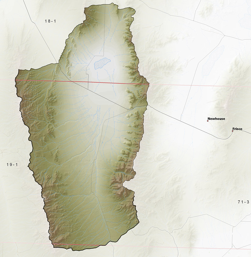
Policy area in green,
click on the map for more detail DESCRIPTION Stretching from southwestern Millard County (T23S) through western Beaver County to the northern border of Iron County (T31S), this isolated drainage basin, of about 730 square miles, includes several intermittent streams that flow from the surrounding mountains to a dry lake bed. It is bounded on the west by the 9,790 foot Needle Range and on the east by the 8,918 foot Wah Wah Mountains. Lower dividing ranges on the northern and southern ends of the valley are about 6,000 feet in elevation. The lowest point is the dry lake bed at 5,075 feet, giving the basin a total relief of about 4,700 feet.Click here to use the Water Rights GIS Map Server to view this area. |
|
|
|