AREA 35 - WEBER AND OGDEN RIVERSUpdated:ĀNovember 3, 2022Recent changes and additions in red text |
|
|
MANAGEMENT The 1937 Weber River Decree and the 1948 Ogden River Decree adjudicated the area's surface water rights prior to those dates. No adjudications have been ordered to update these decrees or include ground-water rights. There are two state-administered distribution systems in this area: the Weber River Distribution System and the Ogden River Distribution System. Parts of the area are also subject to the conditions of two groundwater management plans: the Groundwater Management Plan for the Weber Delta Sub-Area, and the Snyderville/Park City Groundwater Management Plan. Click here to see statistics for this area. SOURCES Surface Water - Surface waters are considered to be fully appropriated. Diligence Claims may be filed on water uses not in the decrees and which were established prior to 1903 for surface water and 1935 for underground water. New diversions and consumptive uses in these sources must be accomplished by change applications filed on owned or acquired rights. Non-consumptive use applications, such as hydroelectric power generation, will be considered on their individual merits. Fixed period or transient projects in canyon or foothill areas must be handled by temporary change applications. Per the State Engineer's Public Meeting Response Letter dated October 26, 2004, new water diversions, based on exchange applications, will be permitted for those projects where there is water available in the proposed source that can be diverted without impairing the rights of others or where water can be released from upstream storage to directly compensate intervening rights that might be impaired. Per the State Engineer's Public Meeting Response Letter dated October 28, 2011: Ground Water - There is a limited ground-water resource available. No new appropriations are approved above the mouths of the canyons. Development of new or different consumptive use projects in these areas must be accomplished by change applications on owned or acquired rights. New appropriations below the canyons are reviewed on an individual basis. Individual domestic filings for 1.0 acre-foot per year are generally approved where a public water supply is not accessible. Larger projects are generally held pending development of approved rights and data from water users. Changes from surface to underground sources, and vice versa, are also considered on their individual merits, with emphasis on their potential to interfere with existing rights and to ensure that there is no enlargement of the underlying rights. Applicants are placed on notice that development should be pursued as soon as possible. Extension of time requests will be critically reviewed beyond the initial five year period. Per the State Engineer's Public Meeting Response Letter dated October 26, 2004, the aquifer test requirement on new wells in the Kamas East Subdivision has been removed. Approvals based on irrigation company stock or leases generally contain conditions requiring maintenance of shares or contracts for the underlying changed rights and/or installation of measuring devices. In some instances, further limitations are imposed as follows: The following are excepted from the effect of this proclamation:
GROUNDWATER MANAGEMENT PLANS STATISTICS FOR CURRENT EXCHANGE APPLICATIONS Ogden RiverWeber River GENERAL Applications are advertised in the Ogden Standard-Examiner, the Morgan County News, the Summit County Bee, or the Park City Record. Filings that may involve the diversion of water in Utah for use in Wyoming (export) would be subject to the special criteria the statutes require for such projects. The general irrigation diversion duty for this area, which the State Engineer uses for evaluation purposes, is 4.0 acre-feet per acre per year (af/ac) in valley regions of western Weber County and 3.0 af/ac in the canyons and upper valleys. The consumptive use requirements are determined from the publication Consumptive Use of Irrigated Crops in Utah, Research Report 145, Utah State University, 1994, unless the applicant submits other data for consideration. This area is administered by the Weber River Regional Office in Salt Lake City. Other requirements The Water Right applicant is strongly cautioned that other permits may be required before any physical development of a project can begin and it is the responsibility of the applicant to determine the applicability of and acquisition of such permits. In order to avoid delays and ensure that Water Right approvals conform to applicable local ordinances, applicants should contact local governmental entities in advance to determine what ordinances are in place that affect the proposed project and to make sure that Water Right filings conform to those ordinances. The approval of a Water Right application does not imply any approval of a project by any other governmental entity. Approval of the project proposed in the Water Right application should be obtained from local governmental entities as necessary to implement a project. REFERENCES Technical Publication No. 2, The Ogden Valley Artesian Reservoir, Weber County, Utah; Utah State Engineer; 1945. Technical Publication No. 27, Water Resources of the Heber-Kamas-Park City Area, North-Central Utah; Utah Department of Natural Resources; 1970. Technical Publication No. 35, Ground-water Conditions in the East Shore Area, Box Elder, Davis, and Weber Counties, Utah, 1960-69; Utah Department of Natural Resources; 1972. Technical Publication No. 76, Reconnaissance of the Quality of Surface Water in the Weber River Basin, Utah; Utah Department of Natural Resources; 1983. Technical Publication No. 77, Ground-water Reconnaissance of the Central Weber River Area, Morgan and Summit Counties, Utah; Utah Department of Natural Resources; 1984. Technical Publication No. 85, Water Resources of the Park City Area, Utah, with Emphasis on Ground Water; Utah Department of Natural Resources; 1986. Technical Publication No. 90, Seepage Studies of the Weber River and the Davis-Weber and Ogden Valley Canals, Davis and Weber Counties, Utah, 1985; Utah Department of Natural Resources; 1987. Technical Publication No. 93, Ground-Water Resources of the East Shore Area of the Great Salt Lake, Utah, and Simulated Effects of Ground-Water Withdrawals; Utah Department of Natural Resources; 1990. Technical Publication No. 99, Hydrology of Ogden Valley and the Surrounding Area, Eastern Weber County, Utah, and Computer Simulation of the Valley-Fill Aquifer System; Utah Department of Natural Resources; 1990. Technical Publication No. 115, Hydrology and snowmelt simulation of Snyderville Basin, Park City, and adjacent areas, Summit County, Utah; Utah Department of Natural Resources; 1998. Basic Data Report No. 1, Records and Water-Level Measurements of Selected Wells and Chemical Analyses of Ground Water, East Shores Areas, Weber and Box Elder Counties, Utah; Utah State Engineer; 1961. Basic Data Report No. 45, Selected Hydrologic Data from Wells in the East Shore Area of the Great Salt Lake, Utah, 1985; Utah Department of Natural Resources; 1986. Information Bulletin No. 9, Projected 1975 Municipal Water Use Requirements, Weber County, Utah; Utah State Engineer; 1962. Water Resource Bulletin No. 29, The Geology of the Kamas-Coalville Region, Summit County, Utah, and its Relation to Ground-Water Conditions; Utah Geological Survey; 2002. Note: Very large download! UGS Special Study, Hydrogeology of Morgan Valley, Morgan County, Utah; Utah Geological Survey; 2011. USGS Scientific Investigations Report 2014-5213, Steady-State Numerical Groundwater Flow Model of the Great Basin Carbonate and Alluvial Aquifer System; 2014. USGS Scientific Investigations Report 2017-5072, Groundwater Model of the Great Basin Carbonate and Alluvial Aquifer System Version 3.0: Incorporating Revisions in Southwestern Utah and East Central Nevada; 2017. UGS Special Study 156, Hydrogeology of the Powder Mountain Area, Weber and Cache Counties, Utah; 2016. UGS Open File Report 670, Forward Modeling of Well Pumpage from the Powder Mountain Carbonate Aquifer, Northern Utah; 2017. UGS Special Study #165 Characterization of the Groundwater System in Ogden Valley, Weber County Utah, Utah Geological Survey; 2019. MODELING Regional Ground-Water Flow, Carbonate-Rock Province, Nevada, Utah, and Adjacent States; USGS Open-File Reports 93-170 and 93-420; 1993. Morgan Valley Ground-water Flow Model; 1984. Ogden Valley Ground-water Flow Model; 1991. Weber Delta Ground-water Flow Model, 1990. PREVIOUS PAGE UPDATES December 24, 2002, June 14, 2004, September 24, 2004, October 26, 2004, April 10, 2011, October 28, 2011, April 3, 2018, October 2, 2019 |
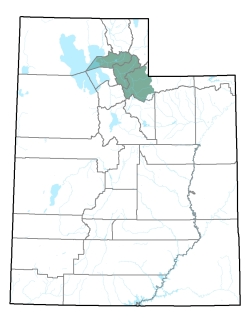
Policy area in green,
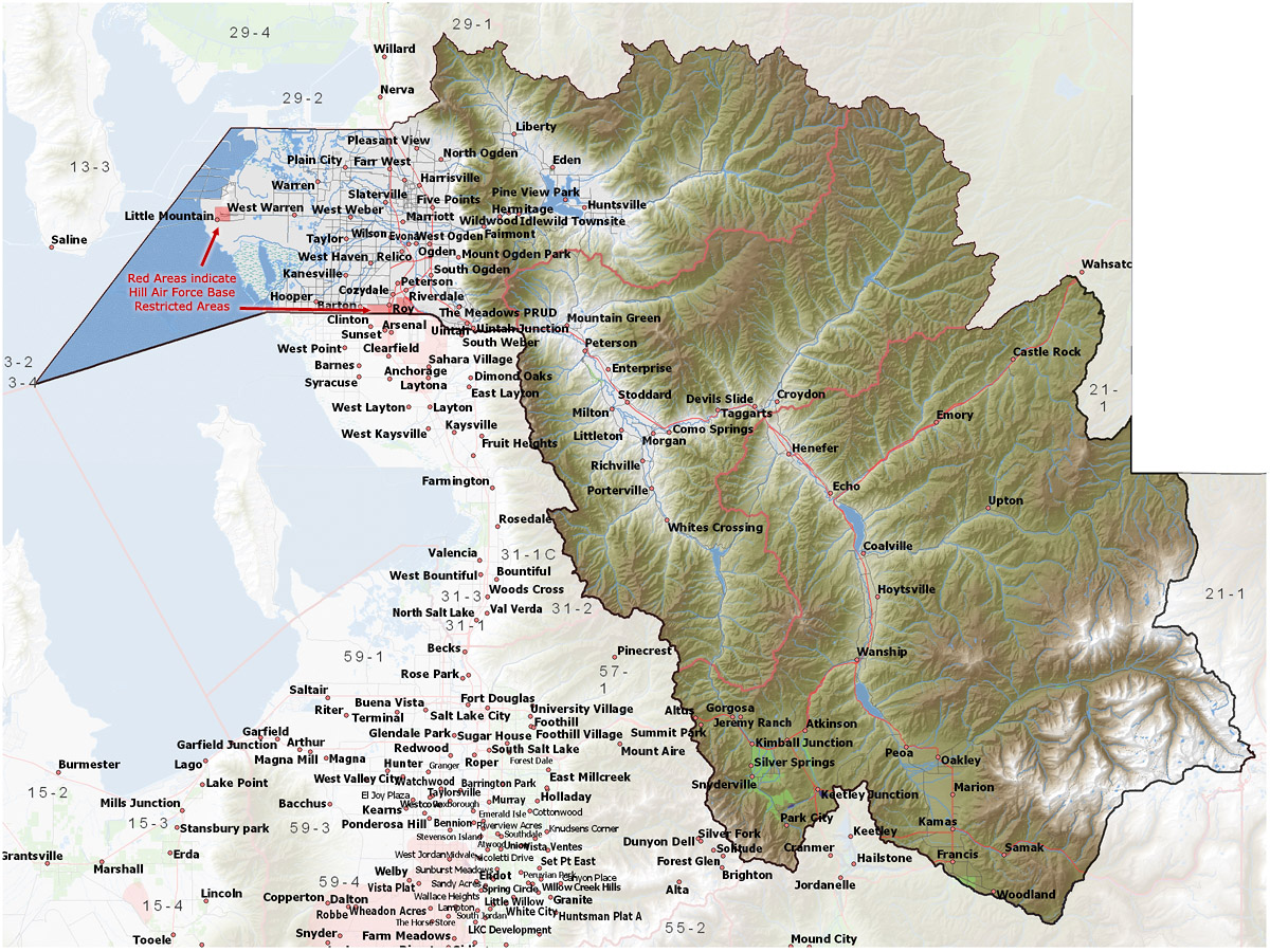
click on the map for more detail DESCRIPTION This area includes the main stem of the Ogden River and its tributaries (North, Middle, and South Forks) in Weber County and the main stem of the Weber River and its tributaries (Beaver Creek, East Canyon Creek, Chalk Creek, Heiners Creek, Lost Creek, and Cottonwood Creek) in Weber, Morgan, and western Summit Counties. |
|
|
|