AREA 67 - PAHVANT VALLEYUpdated:ĀApril 13, 2011 |
|
|
MANAGEMENT The Sevier River Decree of 1937 (issued after compilation of a proposed determination of water rights by the State Engineer in the 1920s) apportioned most surface waters. Some diligence claims have been filed on isolated springs that may have been overlooked by the decree. Click here to see statistics for this area. SOURCES Surface and Ground Water - Under a Governor's Proclamation dated December 19, 1946, the surface waters of the Sevier River Basin were closed to all new appropriations. Since that time, all new development of surface water for consumptive purposes must be based on the acquisition and changing of existing valid surface water rights. As of February 20, 2003, Pahvant Valley is closed to ground-water appropriations. Applications filed prior that time will be processed under the previous policy (Policy Letter). All new water development will be based on the acquisition and changing of existing valid water rights from surface (including direct flow and reservoir storage) and underground sources. The Sevier Basin Ground-Water Policy was subsequently adopted November 5, 1997. Hydropower appropriations that are non-consumptive in nature can be considered on an individual basis. Fixed-period or transient projects must be handled by temporary change applications --even for non-consumptive activities. Most projects are allowed five years to develop and prove beneficial use. Extensions of time are critically reviewed. GROUNDWATER MANAGEMENT PLANS GENERAL Applications in this area are advertised in the Millard County Chronicle Progress newspaper. The general figure for irrigation diversion duty in this area is 4 acre-feet per acre. The consumptive use requirement is determined from the publication Consumptive Use of Irrigated Crops in Utah, Research Report 145, Utah State University, 1994, unless the applicant submits other data for consideration. This area is administered by the Sevier River/Southern Regional Office in Richfield. Other Requirements The Water Right applicant is strongly cautioned that other permits may be required before any physical development of a project can begin and it is the responsibility of the applicant to determine the applicability of and acquisition of such permits. In order to avoid delays and ensure that Water Right approvals conform to applicable local ordinances, applicants should contact local governmental entities in advance to determine what ordinances are in place that affect the proposed project and to make sure that Water Right filings conform to those ordinances. The approval of a Water Right application does not imply any approval of a project by any other governmental entity. Approval of the project proposed in the Water Right application should be obtained from local governmental entities as necessary to implement a project. REFERENCES Water-Resources Investigative Report 95-4173, Simulated Effects of Proposed Ground-Water Pumping in 17 Basins in East-Central and Southern Nevada; U.S. Geological Survey; 1995 (viewing this document requires the DjVu browser plugin available from LizardTech) Technical Publication No. 98, Ground Water Hydrology of Pahvant Valley and Adjacent Areas, Utah. USGS Scientific Investigations Report 2014-5213, Steady-State Numerical Groundwater Flow Model of the Great Basin Carbonate and Alluvial Aquifer System; 2014. USGS Scientific Investigations Report 2017-5072, Groundwater Model of the Great Basin Carbonate and Alluvial Aquifer System Version 3.0: Incorporating Revisions in Southwestern Utah and East Central Nevada; 2017. MODELING None available. PREVIOUS PAGE UPDATES None available. |
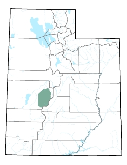
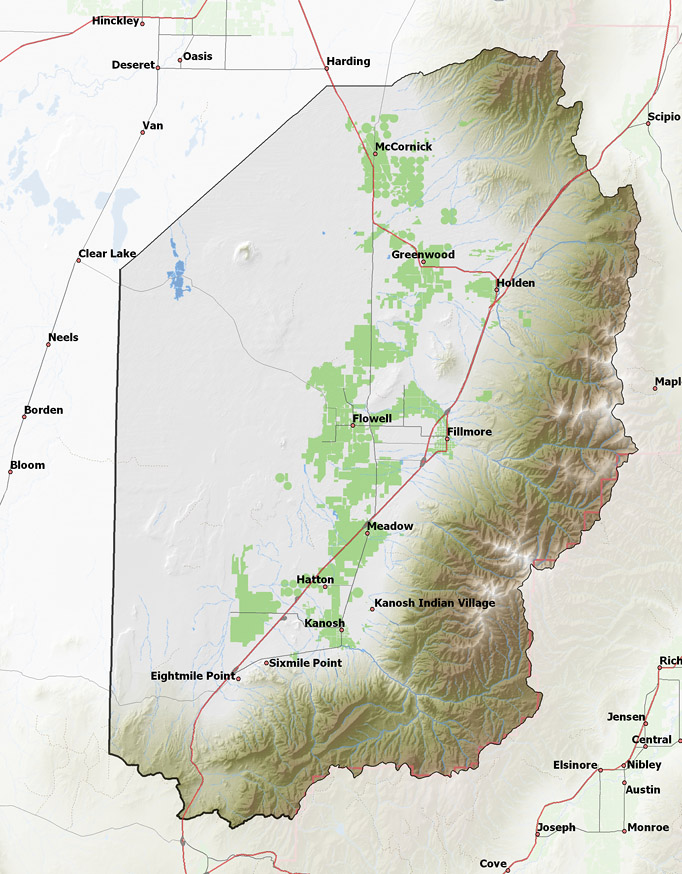
Policy area in green,
click on the map for more detail DESCRIPTION Extending from T17S to T25S in eastern Millard County, this drainage area includes several creeks and large springs that flow westerly toward the Sevier Desert. Although the Sevier River is located to the north of the valley, it can serve the area via canal. |
|
|
|