AREA 81 - VIRGIN RIVERUpdated:ĀApril 17, 2011 |
||||||||||||||||||||||||||||||||||||||||||||||||||||||||
|
MANAGEMENT Rights in the river and its tributaries have been allocated under several court decrees including the Santa Clara Decree in 1922 with a supplemental decree in 1928, the Quail Creek Decree in 1923, and the Virgin River Decree in 1926 with a supplemental and final decree in 1931. Water rights in this area are currently being compiled into Proposed Determinations of Water Rights under the court ordered general adjudication of the Virgin River. The Beaver Dam Wash and Santa Clara River Proposed Determination (Book 1) was submitted to the court in 1988 while the North Fork and East Fork of the Virgin River Proposed Determination (Book 2) was submitted in 1992. No comprehensive pre- trial orders have been issued on either Book 1 or Book 2. An Addendum to Book 1 was distributed in September 1999 in anticipation of a pre-trial order that will affirm all rights excepting those on which objections have been properly filed. In February of 2002, a "Partial Interlocutory Decree" was entered by the Fifth District Court affirming a number of water rights from Book 1. The rights affirmed are those related to a series of agreements designed to create a federal reserved water right for the Shivwits Band of Paiute Indians, whose reservation lands are located in the Santa Clara River drainage. In June/July of 2000, a Proposed Determination (Book 6) covering the state originated and federal reserved rights within Zion National Park was distributed. In January of 2001, an "Interlocutory Decree" was entered by the Fifth District Court affirming the rights in Book 6. Part of this agreement limits the amount of available water that can be developed above the park. Scanned pages of the Zion National Park Settlement Agreement are available online. The following table will be updated to include amounts appropriated and remaining within each subregion after the Division of Water Rights reviews each water right within the region's boundaries to determine accurate and applicable amounts. A map showing the regions and subregions is available as a printable PDF.
In 2009, H.R.146 became law designating as 'Wild and Scenic Rivers' approximately 165.5 miles of segments of the Virgin River and tributaries of the Virgin River across Federal land within and adjacent to Zion National Park, as generally depicted on this map. This designation provides protections which are described in U.S. Code TITLE 16 chapter 28 for these river segments as of the date of the designation. H.R. 146 specifically states that the stream segments within Zion National Park are governed by the 'Zion National Park Rights Settlement Agreement' dated December 4, 1996. The designation of Stream Segments as 'Wild and Scenic Rivers' outside of Zion National Park established a federal reserved water right for the purpose of the reservation with a priority date of 2009. This federal reserved right restricts future appropriation or water right changes that would reduce the flow of the river in these segments. There are three state-administered surface water distribution systems in this area: The East Fork of the Virgin River, the Santa Clara River, and the Virgin River. These systems are under the jurisdiction of the East Fork of the Virgin River Commissioner, the Santa Clara River Commissioner, and the Virgin River Commissioner, respectively. Because this area is tributary to the Colorado River, it is covered under the Colorado River Compact of 1922 and the Mexican Treaty of 1944. However, there are no interstate compacts which specifically apportion the waters of the Virgin River basin. There are three federal reserved water right agreements in force in this area. The Zion National Park Water Right Settlement Agreement deals with National Park Service water rights within the park and affects the administration of the North Fork and East Fork of the Virgin River drainages. The Shivwits Band of the Paiute Indian Tribe of Utah Water Rights Settlement Agreement quantifies the water rights of the Band on the Santa Clara River. The Water Rights Settlement Agreement for Leap, South Ash, Wet Sandy, Leeds and Quail Creeks deals with water right claims in the Dixie National Forest on the southeast flank of the Pine Valley Mountains. Click here to see statistics for this area. SOURCES Surface and Ground Water - The waters of this area are considered to be fully appropriated with a few exceptions described below. New diversions and uses must be accomplished by change applications based on valid existing water rights. Fixed-time projects involving surface waters must be accomplished by temporary change applications on valid existing water rights, which require annual renewal. Change applications proposing a change from surface to underground sources, or vice versa, will be critically reviewed to assure hydrologic connection, that there are no enlargements of the underlying right(s), and that there will be no impairment of other rights. The State Engineer believes there is some unappropriated water available in the aquifer system of the Canaan Gap drainage east of the Hurricane Cliffs and on the Beaver Dam Wash drainage. Domestic filings, limited to the requirements of one family, 1/4 acre of irrigation, and up to ten head of livestock (1.73 acre-feet), or for an equivalent amount of water for other uses, are individually reviewed for potential interference with existing water rights, and some have been approved. Applications are generally approved upon showing of an immediate need for water and with the presumptions that the applicant has all necessary resources and authorities diligently develop the proposed beneficial uses of water and to file proof. Typically, a period of five years is allowed for full development with extensions of time granted only under unique circumstances clearly beyond the control of the applicant. GENERAL Applications are advertised in the Spectrum/Daily News or the Southern Utah News, depending on the county in which the water is to be diverted. Filings that may involve the diversion of water in Utah for use in Arizona or Nevada (export) would be subject to the special criteria the statutes require for such projects. The general irrigation diversion duty for this area, which the State Engineer uses for evaluation purposes, varies between 6.0 acre-feet per acre per year (af/ac) in the low desert to 3.0 af/ac in the highlands. (Click here to see the irrigation duty map of this area). The consumptive use requirement is determined from the publication Consumptive Use of Irrigated Crops in Utah, Research Report 145, Utah State University, 1994, unless the applicant submits other data for consideration. There are approximately 4,400 water rights on file with the State Engineer in this area. This area is administered by the Southwest Regional Office in Cedar City. Other Requirements The Water Right applicant is strongly cautioned that other permits may be required before any physical development of a project can begin and it is the responsibility of the applicant to determine the applicability of and acquisition of such permits. In order to avoid delays and ensure that Water Right approvals conform to applicable local ordinances, applicants should contact local governmental entities in advance to determine what ordinances are in place that affect the proposed project and to make sure that Water Right filings conform to those ordinances. The approval of a Water Right application does not imply any approval of a project by any other governmental entity. Approval of the project proposed in the Water Right application should be obtained from local governmental entities as necessary to implement a project. REFERENCES Technical Publication No. 15; Water from Bedrock in the Colorado Plateau of Utah; Utah State Engineer; 1966. Technical Publication No. 40, Groundwater Conditions in the Central Virgin River Basin, Utah; Utah Department of Natural Resources; 1972. Technical Publication No. 61, Groundwater Conditions in the Navajo Sandstone in the Central Virgin River Basin, Utah; Utah Department of Natural Resources; 1978. Technical Publication No. 70, Groundwater Conditions in the Upper Virgin River and Kanab Creek Basins Area, Utah, with Emphasis on the Navajo Sandstone; Utah Department of Natural Resources; 1981. Technical Publication No. 83, Reconnaissance of the Quality of Surface Water in the Upper Virgin River Basin, Utah, Arizona and Nevada, 1981- 82; Utah Department of Natural Resources; 1985. Technical Publication No. 106, Seepage Study of the Virgin River from Ash Creek to Harrisburg Dome, Washington County, Utah; Utah Department of Natural Resources; 1995. Technical Publication No. 116, Geohydrology and numerical simulation of ground-water flow in the Central Virgin River basin of Iron and Washington Counties, Utah; Utah Department of Natural Resources; 2000. Water-Resources
Investigative Report 95-4173, Simulated Effects of Proposed Ground-Water
Pumping in 17 Basins in East-Central and Southern Nevada; Water-Resources Investigations Report 97-4193, Hydrology and Water Quality of the Beaver Dam Wash Area, Washington County, Utah, Lincoln County, Nevada, and Mohave County, Arizona, U.S. Geological Survey, 1997. USGS Scientific Investigations Report 2014-5213, Steady-State Numerical Groundwater Flow Model of the Great Basin Carbonate and Alluvial Aquifer System; 2014. USGS Scientific Investigations Report 2017-5072, Groundwater Model of the Great Basin Carbonate and Alluvial Aquifer System Version 3.0: Incorporating Revisions in Southwestern Utah and East Central Nevada; 2017. MODELING Regional Ground-Water Flow, Carbonate-Rock Province, Nevada, Utah, and Adjacent States; USGS Open-File Reports 93-170 and 93-420; 1993. Gunlock Area Ground-water Flow Model; 2000. Central Virgin Navajo-Kayenta Ground-water Flow Model; 2000. Upper Ash Creek Ground-water Flow Model; 2000. PREVIOUS PAGE UPDATES |
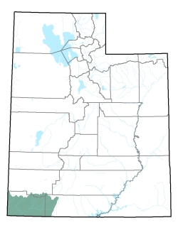
Policy area in green,
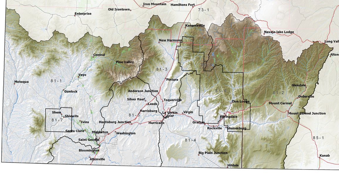
click on the map for more detail DESCRIPTION Covering most of Washington County and the western part of Kane County, this area reaches from T37S to T43S, and is bordered on the west by Nevada and on the south by Arizona. It includes the main stem of the Virgin River from below Zion National Park, through the Hurricane Cliffs to St. George and south to Arizona. Also, in this area are several major tributaries: 1) the East Fork of the Virgin River traversing Long Valley and the White Cliffs area, 2) the North Fork of the Virgin River from Kolob Terrace through Zion Canyon, 3) North Creek out of Kolob Terrace, 4) Ash Creek from the New Harmony area, 5) Quail Creek from the Pine Valley Mountains, and 6) the Santa Clara River entering above St. George. Several reservoirs store winter flows to supplement summer needs. These include Quail Creek, Gunlock, Kolob, Ash Creek, Baker, and Sand Hollow. The area is bounded on the east by the 9,630 foot Paunsagunt Plateau and on the north by the 7,514 foot Cougar Mountains, the 10,238 foot Pine Valley Mountain, and the 10,027 foot Markagunt Plateau. The lowest point is where Beaver Dam Wash crosses the border into Arizona at 2,199 feet, giving the area a total relief of about 8,040 feet. |
|||||||||||||||||||||||||||||||||||||||||||||||||||||||
|
|
||||||||||||||||||||||||||||||||||||||||||||||||||||||||
 East Fork Virgin River